Scottsville Screen Test
This is a test boundary screened against public map layers, not a real project.
Map screen
?
The project boundary screened against public map layers.
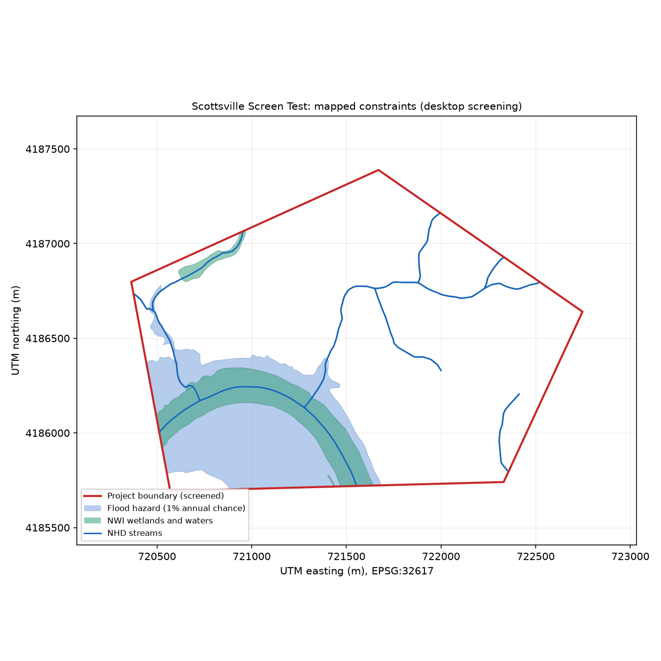
Summary
- Boundary source
- auto
- Boundary document
- DR-0001
- Feature
- Project Boundary
- Rule
- only polygon document, single feature
- Acres
- 713.79
- Perimeter in miles
- 4.11
- Geometry SHA-256
- 9a467b459c29c0c77a52b7bf3fc74ac342c83f06fca792a5036cdab6c0eefa80
- Layers
- 16
- Findings
- 41
- Network calls
- 8
- Cache hits
- 91
- Required layers that failed
- None
- Accepted gaps
- None
- Mirrors allowed
- Yes
- Ran at
- 2026-10-02T16:38:31+00:00
Layers
Boundary, county and state
location
- Status
- ok
- Authoritative source
- Yes
- Exists only as today's version
- Yes
- Findings
- 5
- Metrics
- acres
- 713.79
- counties
- county
- Fluvanna County
- state
- VA
- acres
- 449.51
- county
- Albemarle County
- state
- VA
- acres
- 157.46
- county
- Buckingham County
- state
- VA
- acres
- 106.84
- representative_point
- 37.796, -78.48415
FEMA flood hazard zones
fema_flood
- Status
- partial
- Authoritative source
- No
- Exists only as today's version
- Yes
- Findings
- 4
- Notes
- Authoritative FEMA service unreachable (service metadata https://hazards.fema.gov/arcgis/rest/services/public/NFHL/MapServer: SSLError: HTTPSConnectionPool(host); used the Esri Living Atlas copy.
- The mirror omits minimal-hazard Zone X areas; digital map coverage cannot be measured from it.
- FIRM panel effective dates are not available from the mirror; the as-of status of the flood map cannot be confirmed from this source.
- Metrics
- acres_by_zone
- AE
- 27.12
- AE (Floodway)
- 143.78
- X (0.2 Percent Annual Chance Flood Hazard)
- 4.44
- X (Area With Reduced Flood Risk Due To Levee)
- 13.93
- sfha_acres
- 170.9
- floodway_acres
- 143.78
- x_0_2pct_acres
- 4.44
- digital_coverage_ratio
- 0.2652
USFWS National Wetlands Inventory
nwi_wetlands
- Status
- ok
- Authoritative source
- Yes
- Exists only as today's version
- Yes
- Findings
- 2
- Notes
- NWI mapping-status layer not read: NWI mapping status ids: HTTP 500
- Metrics
- acres_by_type
- Freshwater Emergent Wetland
- 0.54
- Freshwater Forested/Shrub Wetland
- 3.65
- Freshwater Pond
- 3.28
- Riverine
- 58.39
- acres_by_code
- R2UBH
- 52.18
- R4SBC
- 6.18
- PFO1A
- 3.65
- PUBHh
- 3.28
- PEM1F
- 0.32
- PEM1Fh
- 0.22
- R5UBH
- 0.02
- acres_total
- 65.86
- polygons_inside
- 12
- polygons_within_quarter_mile_outside
- 13
USGS National Hydrography Dataset (high resolution)
nhd_hydrography
- Status
- ok
- Authoritative source
- Yes
- Exists only as today's version
- Yes
- Findings
- 3
- Metrics
- feet_by_type
- artificial path (centerline through a waterbody)
- 5852
- intermittent stream
- 14448
- stream_feet
- 20300
- named_streams_feet
- James River
- 4488
- waterbody_acres
- 3.72
- waterbodies
- Mink Creek (3.7 ac)
- area_feature_acres
- 51.12
USGS Watershed Boundary Dataset (HUC-12)
wbd_watersheds
- Status
- ok
- Authoritative source
- Yes
- Exists only as today's version
- Yes
- Findings
- 1
- Metrics
- huc12
- huc12
- 020802031104
- name
- Little George Creek-James River
- acres
- 713.79
NRCS soil survey (SSURGO)
ssurgo_soils
- Status
- ok
- Authoritative source
- Yes
- Exists only as today's version
- Yes
- Findings
- 6
- Metrics
- hydric_all
- 3.71
- hydric_partial
- 124.21
- prime
- 97.03
- prime_if
- 30.34
- statewide
- 85.26
- shallow_rock
- 399
- shallow_water
- 3.71
- flooding
- 121.93
- covered_acres
- 713.79
- coverage_ratio
- 1
- map_units
- 30
NLCD 2019 land cover
nlcd_land_cover
- Status
- ok
- Authoritative source
- Yes
- Exists only as today's version
- No
- Findings
- 3
- Metrics
- 2019
- year
- 2019
- coverage_id
- mrlc_download__NLCD_2019_Land_Cover_L48
- resolution_m
- 30
- classes
- code
- 11
- name
- Open water
- acres
- 55.15
- code
- 21
- name
- Developed, open space
- acres
- 71.83
- code
- 22
- name
- Developed, low intensity
- acres
- 42.03
- code
- 23
- name
- Developed, medium intensity
- acres
- 24.91
- code
- 24
- name
- Developed, high intensity
- acres
- 8.67
- code
- 41
- name
- Deciduous forest
- acres
- 223.73
- code
- 42
- name
- Evergreen forest
- acres
- 44.92
- code
- 43
- name
- Mixed forest
- acres
- 155.45
- code
- 52
- name
- Shrub/scrub
- acres
- 6.89
- code
- 71
- name
- Grassland/herbaceous
- acres
- 7.34
- code
- 81
- name
- Pasture/hay
- acres
- 36.92
- code
- 82
- name
- Cultivated crops
- acres
- 33.8
- code
- 90
- name
- Woody wetlands
- acres
- 1.11
- code
- 95
- name
- Emergent herbaceous wetlands
- acres
- 0.89
- groups
- forest
- 424.11
- agriculture
- 70.72
- developed
- 147.45
- wetlands
- 2
- water
- 55.15
- shrub_grass
- 14.23
- barren
- 0
- largest_forest_patch_acres
- 186.1
- forest_patches_over_50_acres
- 3
- boundary_acres_albers
- 713.79
- counted_acres
- 713.67
- nodata_acres
- 0
- unknown_codes
- []
- coverage_ratio
- 0.9998
- source
- service
- https://www.mrlc.gov/geoserver/mrlc_download/wcs
- response_sha256
- 96eec57ac885bba5e7e3fd2d81daa7f3fbb41a15ac12e81017790d29087ad37d
- retrieved_at
- 2026-10-02T16:05:21+00:00
- request_key
- 93fa9a3a50ca8dfeee15bdf2e68f1455efb51564607fb9b68226c9ac06a0c97b
- 2021_reference_only
- year
- 2021
- coverage_id
- mrlc_download__NLCD_2021_Land_Cover_L48
- resolution_m
- 30
- classes
- code
- 11
- name
- Open water
- acres
- 55.15
- code
- 21
- name
- Developed, open space
- acres
- 71.83
- code
- 22
- name
- Developed, low intensity
- acres
- 42.03
- code
- 23
- name
- Developed, medium intensity
- acres
- 24.91
- code
- 24
- name
- Developed, high intensity
- acres
- 8.67
- code
- 41
- name
- Deciduous forest
- acres
- 219.73
- code
- 42
- name
- Evergreen forest
- acres
- 17.35
- code
- 43
- name
- Mixed forest
- acres
- 135.44
- code
- 52
- name
- Shrub/scrub
- acres
- 6.89
- code
- 71
- name
- Grassland/herbaceous
- acres
- 58.93
- code
- 81
- name
- Pasture/hay
- acres
- 36.92
- code
- 82
- name
- Cultivated crops
- acres
- 33.8
- code
- 90
- name
- Woody wetlands
- acres
- 1.11
- code
- 95
- name
- Emergent herbaceous wetlands
- acres
- 0.89
- groups
- forest
- 372.51
- agriculture
- 70.72
- developed
- 147.45
- wetlands
- 2
- water
- 55.15
- shrub_grass
- 65.83
- barren
- 0
- largest_forest_patch_acres
- 137
- forest_patches_over_50_acres
- 3
- boundary_acres_albers
- 713.79
- counted_acres
- 713.67
- nodata_acres
- 0
- unknown_codes
- []
- coverage_ratio
- 0.9998
- source
- service
- https://www.mrlc.gov/geoserver/mrlc_download/wcs
- response_sha256
- 7256d1eb77dc3cbc2617019de9eeec78a8a0a50db1d4cc42c3b645ea47110022
- retrieved_at
- 2026-10-02T16:05:23+00:00
- request_key
- ca56a8a4fe758145012b8fe30dfd12614ec685e2a054621f4e73645d0736b922
USGS 3DEP elevation and slope
dem_slope
- Status
- ok
- Authoritative source
- Yes
- Exists only as today's version
- Yes
- Findings
- 2
- Metrics
- resolution_m
- 3
- pixels_inside
- 321086
- boundary_acres_utm
- 714.08
- counted_acres
- 714.08
- nodata_acres
- 0
- coverage_ratio
- 1
- slope_classes
- class
- 0-5%
- acres
- 163.83
- class
- 5-10%
- acres
- 102.68
- class
- 10-15%
- acres
- 105.6
- class
- 15-20%
- acres
- 93.3
- class
- 20-30%
- acres
- 127.17
- class
- >=30%
- acres
- 121.5
- slope_mean_pct
- 17.5
- slope_p90_pct
- 37.8
- elev_min_ft
- 259
- elev_max_ft
- 478
- acres_over_15pct
- 341.97
- acres_over_25pct
- 173.53
- source
- service
- https://elevation.nationalmap.gov/arcgis/rest/services/3DEPElevation/ImageServer
- description
- The USGS 3D Elevation Program (3DEP) Bare Earth DEM Dynamic service is based on multi-resolution USGS DEM sources and provides dynamic functions for visualization. These functions include: Hillshade, Aspect Map, Hillshade Stretched, Multi-directional Hillshade, Slope Map, Elevation Tinted Hillshade,
- response_sha256
- 8fd2eb442e55e8b621a9e8a216d8c9d2473231ad7fafb1c63233a085cfad4c0f
- retrieved_at
- 2026-10-02T16:05:31+00:00
- request_key
- 07b53a8bd177b843883fd2bf83ca4dab9a3f67530686e2a7106e684977493bb0
USGS karst map of the United States (2014)
usgs_karst
- Status
- ok
- Authoritative source
- Yes
- Exists only as today's version
- No
- Findings
- 1
- Metrics
- inside
- []
- nearest_outside_miles
- 1.26
USFWS IPaC species list, status as of the cut-off
usfws_ipac
- Status
- ok
- Authoritative source
- Yes
- Exists only as today's version
- Yes
- Findings
- 7
- Metrics
- field_office
- Virginia Ecological Services Field Office
- species
- sci
- Lasmigona subviridis
- common
- Green floater
- group
- Clams
- ipac_status_code
- PT
- ipac_status_name
- Proposed Threatened
- as_of_code
- PT
- as_of_phrase
- proposed threatened
- events
- date
- 2023-07-26
- kind
- proposed_T
- citation
- 88 FR 48294
- title
- Endangered and Threatened Wildlife and Plants; Threatened Species Status With Section 4(d) Rule for Green Floater and Designation of Critical Habitat
- published
- 2023-07-26
- document_number
- 2023-15143
- reconstructed_current
- PT
- consistent
- true
- note
- crithab_in_footprint
- false
- profile_url
- https://ecos.fws.gov/ecp/species/7541
- conditions
- sci
- Parvaspina collina
- common
- James spinymussel
- group
- Clams
- ipac_status_code
- E
- ipac_status_name
- Endangered
- as_of_code
- E
- as_of_phrase
- endangered
- events
- date
- 1988-07-22
- kind
- final_E
- citation
- ECOS original listing date
- title
- Original ESA listing (date from ECOS)
- published
- 1988-07-22
- document_number
- reconstructed_current
- E
- consistent
- true
- note
- crithab_in_footprint
- false
- profile_url
- https://ecos.fws.gov/ecp/species/2212
- conditions
- sci
- Danaus plexippus
- common
- Monarch butterfly
- group
- Insects
- ipac_status_code
- PT
- ipac_status_name
- Proposed Threatened
- as_of_code
- C
- as_of_phrase
- a candidate
- events
- date
- 2020-12-17
- kind
- candidate
- citation
- 85 FR 81813
- title
- Endangered and Threatened Wildlife and Plants; 12-Month Finding for the Monarch Butterfly
- published
- 2020-12-17
- document_number
- 2020-27523
- date
- 2024-12-12
- kind
- proposed_T
- citation
- 89 FR 100662
- title
- Endangered and Threatened Wildlife and Plants; Threatened Species Status With Section 4(d) Rule for Monarch Butterfly and Designation of Critical Habitat
- published
- 2024-12-12
- document_number
- 2024-28855
- reconstructed_current
- PT
- consistent
- true
- note
- crithab_in_footprint
- false
- profile_url
- https://ecos.fws.gov/ecp/species/9743
- conditions
- migratory_birds
- Bald Eagle, Chimney Swift, Grasshopper Sparrow, Kentucky Warbler, Prairie Warbler, Prothonotary Warbler, Red-headed Woodpecker, Rusty Blackbird, Wood Thrush
- bcc
- []
- eagles
- Bald Eagle
- crithabs_raw
- 0
USFWS critical habitat (final and proposed)
usfws_critical_habitat
- Status
- ok
- Authoritative source
- Yes
- Exists only as today's version
- Yes
- Findings
- 1
- Metrics
- within_5_miles
- []
National Register of Historic Places (NPS spatial data)
nps_nrhp
- Status
- ok
- Authoritative source
- Yes
- Exists only as today's version
- Yes
- Findings
- 1
- Metrics
- within_1_mile
- name
- Mount Walla
- ref
- 00001442
- type
- building
- certified
- null
- nhl
- null
- miles
- 0
- name
- Scottsville Historic District (Boundary Increase)
- ref
- 04000034
- type
- district
- certified
- null
- nhl
- null
- miles
- 0
- name
- Southern Albemarle Rural Historic District
- ref
- 07001236
- type
- district
- certified
- null
- nhl
- null
- miles
- 0
- name
- Scottsville Historic District
- ref
- 76002093
- type
- district
- certified
- null
- nhl
- null
- miles
- 0
- name
- Cliffside
- ref
- 82004536
- type
- building
- certified
- null
- nhl
- null
- miles
- 0.08
- name
- Scottsville Tire Cord Plant
- ref
- 100010041
- type
- district
- certified
- null
- nhl
- null
- miles
- 0.12
- name
- High Meadows
- ref
- 86001185
- type
- building
- certified
- null
- nhl
- null
- miles
- 0.51
Protected areas and conservation easements (PAD-US)
padus_protected
- Status
- ok
- Authoritative source
- Yes
- Exists only as today's version
- Yes
- Findings
- 1
- Notes
- PAD-US layers: PADUS4_1ProtMechCat
- Metrics
No metrics recorded.
Electric transmission lines (HIFLD)
hifld_transmission
- Status
- ok
- Authoritative source
- No
- Exists only as today's version
- Yes
- Findings
- 1
- Metrics
No metrics recorded.
FAA airports and heliports
faa_airports
- Status
- ok
- Authoritative source
- Yes
- Exists only as today's version
- Yes
- Findings
- 1
- Metrics
No metrics recorded.
Species occurrence records before the cut-off (GBIF: eBird, iNaturalist and others)
gbif_occurrences
- Status
- ok
- Authoritative source
- No
- Exists only as today's version
- Yes
- Findings
- 2
- Metrics
- total
- 4092
- species
- 327
- by_taxon
- Lasmigona subviridis
- count
- 0
- years
- []
- datasets
- []
- Parvaspina collina
- count
- 0
- years
- []
- datasets
- []
- Danaus plexippus
- count
- 0
- years
- []
- datasets
- []
- datasets
- 4fa7b334-ce0d-4e88-aaae-2e0c138d049e, 3759
- 50c9509d-22c7-4a22-a47d-8c48425ef4a7, 217
- 82cb293c-f762-11e1-a439-00145eb45e9a, 52
- 14d5676a-2c54-4f94-9023-1e8dcd822aa0, 19
- 821cc27a-e3bb-4bc5-ac34-89ada245069d, 9
- 07afc988-ad0b-4664-890e-96ac643ffbc7, 8
- d6cc311c-c5ab-4f23-9a20-10514f9eb9c4, 7
- 3ab13bbb-8efa-4f6a-838b-b6a8eaa3f4df, 5
- 7e97cc7b-929e-4ce3-be97-504328101673, 5
- d415c253-4d61-4459-9d25-4015b9084fb0, 4