Skip to content

Standard Flood Hazard Determination - Tamsin Ridge Parcels 5, 9 and 10

C-0caa870c61 · Page 1 of 1 · DR-0009 · 2023-03-15

The claim, in the assessor's words

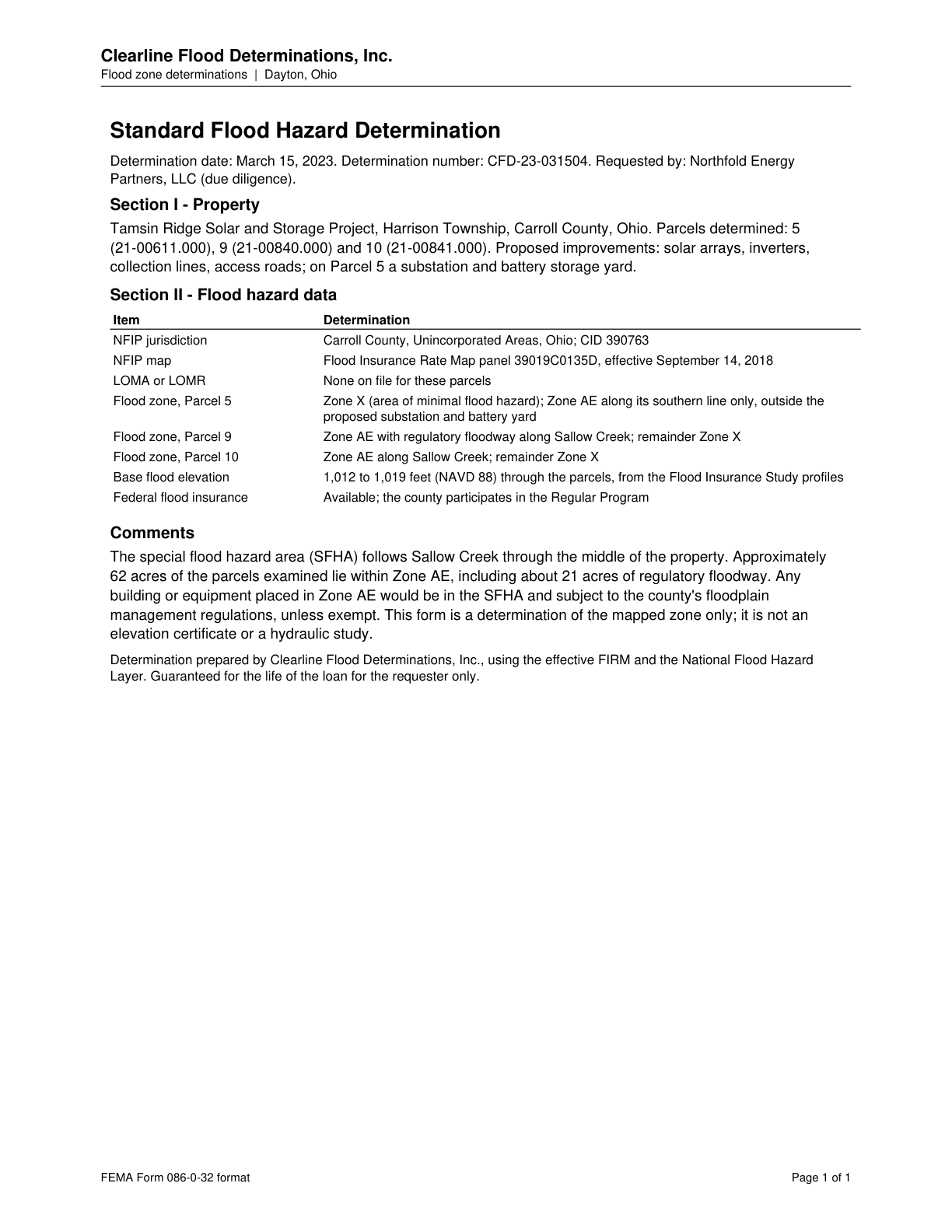
Proposed improvements include solar arrays, inverters, collection lines, access roads; Parcel 5 would host a substation and battery storage yard.

Quoted from page 1
Proposed improvements: solar arrays, inverters, collection lines, access roads; on Parcel 5 a substation and battery storage yard.

Source consultant_memo · Claim type project_fact · Polarity neutral · Confidence high · Quote check exact, 100 of 100

Cited by EG-04 Battery Storage Fire Safety · Filed under EG-04, EN-01, PE-03

States the fact project.technology = solar PV and battery storage

On the page

The page text exactly as the engine read it, with the quote marked.

Placed normalised · The quote matches the page once line breaks, hyphenation, case and punctuation are set aside, as the engine's matcher compares text. The marked words are the page's own.

Read as native

Go to the marked quote

Clearline Flood Determinations, Inc. Flood zone determinations | Dayton, Ohio Standard Flood Hazard Determination Determination date: March 15, 2023. Determination number: CFD-23-031504. Requested by: Northfold Energy Partners, LLC (due diligence). Section I - Property Tamsin Ridge Solar and Storage Project, Harrison Township, Carroll County, Ohio. Parcels determined: 5 (21-00611.000), 9 (21-00840.000) and 10 (21-00841.000). Quote starts. Proposed improvements: solar arrays, inverters, collection lines, access roads; on Parcel 5 a substation and battery storage yard. Quote ends. Section II - Flood hazard data Item Determination NFIP jurisdiction Carroll County, Unincorporated Areas, Ohio; CID 390763 NFIP map Flood Insurance Rate Map panel 39019C0135D, effective September 14, 2018 LOMA or LOMR None on file for these parcels Flood zone, Parcel 5 Zone X (area of minimal flood hazard); Zone AE along its southern line only, outside the proposed substation and battery yard Flood zone, Parcel 9 Zone AE with regulatory floodway along Sallow Creek; remainder Zone X Flood zone, Parcel 10 Zone AE along Sallow Creek; remainder Zone X Base flood elevation 1,012 to 1,019 feet (NAVD 88) through the parcels, from the Flood Insurance Study profiles Federal flood insurance Available; the county participates in the Regular Program Comments The special flood hazard area (SFHA) follows Sallow Creek through the middle of the property. Approximately 62 acres of the parcels examined lie within Zone AE, including about 21 acres of regulatory floodway. Any building or equipment placed in Zone AE would be in the SFHA and subject to the county's floodplain management regulations, unless exempt. This form is a determination of the mapped zone only; it is not an elevation certificate or a hydraulic study. Determination prepared by Clearline Flood Determinations, Inc., using the effective FIRM and the National Flood Hazard Layer. Guaranteed for the life of the loan for the requester only. FEMA Form 086-0-32 format Page 1 of 1

The page

The outline marks where the quote begins on the page.
Page 1 of Standard Flood Hazard Determination - Tamsin Ridge Parcels 5, 9 and 10

Other claims quoted on this page

  • C-beb33132a9

    No LOMA or LOMR is on file for these parcels.

  • C-417a553cb9

    Parcel 5 is mostly Zone X, with Zone AE along its southern line only, outside the proposed substation and battery yard.

  • C-d0039fd7b9

    Parcel 9 is in Zone AE with a regulatory floodway along Sallow Creek; the remainder is Zone X.

  • C-81e2af2ba0

    Parcel 10 lies in Zone AE along Sallow Creek; the remainder is Zone X.

  • C-29b335e462

    The SFHA follows Sallow Creek through the middle of the property.

  • C-0c116fdc65

    Approximately 62 acres of the examined parcels lie within Zone AE, including about 21 acres of regulatory floodway.

  • C-5edaac1379

    Buildings or equipment placed in Zone AE would be in the SFHA and subject to county floodplain management regulations, unless exempt.

Lumerian Labs 2026