Code computed the rating from the assessor's inputs:
extent=core, avoidable=partly -> 3
Set by the rule
Decision
Released with flags
The engine's reasons
Independent assessments split on the category (7 samples: {'2': 2, '3': 4, '1': 1}); reviewer to confirm
Evidence state
Verified · field study or agency determination
Worst case
The same rule on the worst case gives no rating above the point.
Scenario
The lessee's second pad and pipeline easement rights, with right to add lines, conflict with the array and substation/BESS yard on Parcels 2 and 5, requiring uncertain easement releases or relocation.
Step still pending
Site constraints mapping and negotiations with Brenwick Exploration and Calder Gathering
Documents describe constraining features: 138 kV line across the West Block (C-ad2c42da82), gathering pipeline across Parcels 5, 7 and 10 (C-bf7087e782), plugged wells and abandoned mine (C-a3cebd779c, C-d9db0a1832). The farming/no-industrial-use statement (C-e9a687c1a0) concerns historic industrial use and does not negate these features.
The 138 kV line crosses the West Block (C-ad2c42da82); the gathering pipeline, 50-foot easement, transmission ROW and oil and gas lease encumber Parcel 5, which hosts the substation and BESS yard (C-df8aadf77e, C-f23ef8892f, C-c22072d6dc, C-dcf3900993); the abandoned mine lies beneath the eastern part (C-d9db0a1832). Features cross the site and key facilities.
Setbacks (100 feet from plugged wells, operator setbacks) allow siting around most features (C-28570f896a, C-af471048ff). However, the lessee's planned second pad overlaps about 9 acres of the array layout (C-7d33945087), the lessee holds surface-use rights (C-dcf3900993), and the substation sits on an encumbered parcel (C-df8aadf77e); no layout or constraints map is in the data room, so full avoidance is not shown.
Crossing agreements with Calder Gathering (C-d257ecfe8e), operator and ODNR setbacks, and coordination with the oil and gas lessee are standard consents and setbacks; no documented relocation with uncertain outcome.
Pipeline, ROW, well setbacks and the lessee pad overlap (about 9 acres) remove buildable area and constrain layout, including on the substation/BESS parcel (C-7d33945087, C-28570f896a, C-f23ef8892f, C-df8aadf77e).
Existing 138 kV line crosses the West Block. Gas gathering pipeline crosses Parcels 5, 7 and 10; Parcel 5 also carries an oil and gas lease. Two plugged wells and abandoned mine workings are present. Lessee's planned second pad overlaps about 9 acres of the array layout.
Critique
Verdict
upheld
Suggested direction for the rating
same
Summary
The assessment is largely supported by the cited quotes. Category 3 (core, partly avoidable) is reasonable and the worst case names real pending steps. Remaining issues are minor: inferences beyond truncated quotes, a misdescribed absence claim, and no mine-subsidence next step.
Critic model
Luminol
Issues
Severity minor · Kind unsupported_statement
Quotes are truncated. C-7d33945087 ends at 'overlaps about 9 acres of the', so 'array layout' is inferred. C-f23ef8892f ends at 'with the right to', so 'right to add lines' in the worst case is inferred. The ROW and easement are tied to Parcel 5 only through the DR-0005 table row. The full text of DR-0006 and DR-0005 would settle these.
The rationale says the 'No industrial use was found' claim concerns historic industrial use and farming. The quote states neither, and the 'farming' reading is not shown.
The abandoned Elsby No. 2 mine beneath the eastern part of the site is counted toward extent, but it does not appear in avoidability, the setbacks or the next steps. A mine-subsidence and geotechnical review with ODNR Mineral Resources records is not proposed.
Structures should be kept at least 100 feet from plugged wells and follow the operator's setbacks from the pad and flowlines.
Quote check Exact · Placed verbatim · The quote occurs on the page exactly as written. · Read as native
Graywacke Geotechnical, LLC
Geotechnical engineering and subsurface exploration | Canton, Ohio
Preliminary Geotechnical Engineering Report
Tamsin Ridge Solar and Storage Project, Harrison Township, Carroll County, Ohio
Prepared for Northfold Energy Partners, LLC. Project G23-0219. May 15, 2023.
Summary of findings
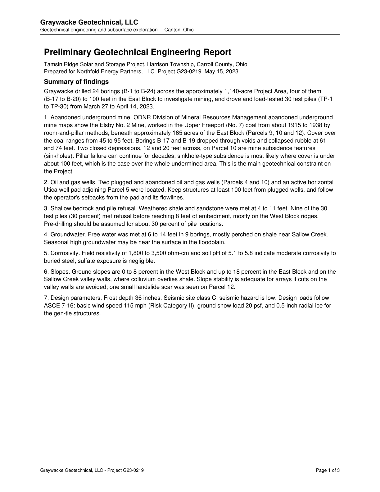
Graywacke drilled 24 borings (B-1 to B-24) across the approximately 1,140-acre Project Area, four of them
(B-17 to B-20) to 100 feet in the East Block to investigate mining, and drove and load-tested 30 test piles (TP-1
to TP-30) from March 27 to April 14, 2023.
1. Abandoned underground mine. ODNR Division of Mineral Resources Management abandoned underground
mine maps show the Elsby No. 2 Mine, worked in the Upper Freeport (No. 7) coal from about 1915 to 1938 by
room-and-pillar methods, beneath approximately 165 acres of the East Block (Parcels 9, 10 and 12). Cover over
the coal ranges from 45 to 95 feet. Borings B-17 and B-19 dropped through voids and collapsed rubble at 61
and 74 feet. Two closed depressions, 12 and 20 feet across, on Parcel 10 are mine subsidence features
(sinkholes). Pillar failure can continue for decades; sinkhole-type subsidence is most likely where cover is under
about 100 feet, which is the case over the whole undermined area. This is the main geotechnical constraint on
the Project.
2. Oil and gas wells. Two plugged and abandoned oil and gas wells (Parcels 4 and 10) and an active horizontal
Utica well pad adjoining Parcel 5 were located. Quote starts. Keep structures at least 100 feet from plugged wells, and follow
the operator's setbacks from the pad and its flowlines. Quote ends.
3. Shallow bedrock and pile refusal. Weathered shale and sandstone were met at 4 to 11 feet. Nine of the 30
test piles (30 percent) met refusal before reaching 8 feet of embedment, mostly on the West Block ridges.
Pre-drilling should be assumed for about 30 percent of pile locations.
4. Groundwater. Free water was met at 6 to 14 feet in 9 borings, mostly perched on shale near Sallow Creek.
Seasonal high groundwater may be near the surface in the floodplain.
5. Corrosivity. Field resistivity of 1,800 to 3,500 ohm-cm and soil pH of 5.1 to 5.8 indicate moderate corrosivity to
buried steel; sulfate exposure is negligible.
6. Slopes. Ground slopes are 0 to 8 percent in the West Block and up to 18 percent in the East Block and on the
Sallow Creek valley walls, where colluvium overlies shale. Slope stability is adequate for arrays if cuts on the
valley walls are avoided; one small landslide scar was seen on Parcel 12.
7. Design parameters. Frost depth 36 inches. Seismic site class C; seismic hazard is low. Design loads follow
ASCE 7-16: basic wind speed 115 mph (Risk Category II), ground snow load 20 psf, and 0.5-inch radial ice for
the gen-tie structures.
Graywacke Geotechnical, LLC - Project G23-0219 Page 1 of 3
The outline marks where the quote begins on the page.
C-28570f896a
Structures should be kept at least 100 feet from plugged wells and follow the operator's setbacks from the pad and flowlines.
Quoted from page 1
Keep structures at least 100 feet from plugged wells, and follow
the operator's setbacks from the pad and its flowlines.
The easement crosses the Calder Gathering Company natural gas gathering line, requiring the grantee to obtain a written crossing agreement and keep required clearance.
Quoted from page 1
Grantee will obtain that company's written crossing agreement and keep the clearance it requires.
Records show abandoned underground Elsby No. 2 Mine beneath the eastern part of the project area, plus pre-1977 reclaimed surface mining.
Quoted from page 1
Division records show abandoned underground coal mining, the Elsby No. 2 Mine in the Upper Freeport (No. 7)
coal, beneath the eastern part of the project area
Comments
Existing 138 kV line crosses the West Block. Gas gathering pipeline crosses Parcels 5, 7 and 10; Parcel 5 also carries an oil and gas lease. Two plugged wells and abandoned mine workings are present. Lessee's planned second pad overlaps about 9 acres of the array layout.