Skip to content

Vegetation and Habitat

EC-03 · Matrix · Ecological Resources

Rating
2Impacts likely but may be easily resolved
Why
Impact likely
Worst case
Not above the rating
Evidence
Verified
Cited claims
14
Requirements
0
Requests
3

Rating

2Impacts likely but may be easily resolved

The engine shows this rating as 2

The rule

Code computed the rating from the assessor's inputs:

impact_likely=yes -> 2

Set by the rule

Decision
Released with flags
The engine's reasons
  • Agencies not in the register or the evidence: USFWS, Carroll County
Evidence state
Verified · field study or agency determination

Worst case

The same rule on the worst case gives no rating above the point.

Scenario

The East Block woodlots prove larger than mapped and the final layout clears more than 38 acres, but forest stays a small share of the site, so mitigation and seasonal windows remain routine.

Step still pending
Survey of the inaccessible East Block woodlots and final layout design
Inputs in the worst case
Extent peripheral · Avoidable partly · Pathway standard · Impact likely yes
The rule on the worst case
worst case (impact_likely=yes -> 2) not above the point
Claims that make it plausible
C-421d66e93e, C-c0e63f6881, C-9d4b1ab8e4

Revision

First verdict
weakened
First critique

Category 2 is plausible, but the 41-acre forest figure and the multiflora rose and heavy-invasion claims are not in the cited quotes. The "limit to 38 acres" recommendation is misattributed, and W-3 is described as a stand when the quote calls it a wetland stand.

Revised once after the first critique. Rating unchanged.

The five inputs

  • Present: yes

    Land cover includes woodlots along Sallow Creek and on reclaimed mine ground in the East Block (C-9d4b1ab8e4), riparian forest lining most of Sallow Creek (C-e10af45ca9), and a draft layout that clears about 38 acres of trees (C-c0e63f6881). Canada thistle, a state noxious weed, is scattered on field edges (C-08f3573546). The survey found no native prairie remnants, rare natural communities or old-growth forest (C-100c2c5e80); that absence covers those communities only, and parts of the East Block woodlots were not accessible (C-421d66e93e), so it is not complete for those areas.

    Cites C-9d4b1ab8e4, C-e10af45ca9, C-c0e63f6881, C-08f3573546, C-100c2c5e80, C-421d66e93e

  • Extent: peripheral

    Cropland is 818 acres (72%) and reclaimed grassland 80 acres (7%) of the Project Area (C-67ba142a5a, C-a6c169a2d9). Woodlots sit along Sallow Creek and on East Block reclaimed ground (C-9d4b1ab8e4), and the draft layout clears about 38 acres of trees (C-c0e63f6881), small against 780 buildable acres. This is a judgment: some East Block woodlots were not accessible (C-421d66e93e), so their extent is not fully verified, and corridor or fragmentation effects are not documented.

    Cites C-67ba142a5a, C-a6c169a2d9, C-9d4b1ab8e4, C-c0e63f6881, C-421d66e93e

  • Avoidable: partly

    The draft layout clears about 38 acres of trees (C-c0e63f6881). The consultant recommends avoiding the riparian forest and the W-3 wetland stand (C-b1fad0c404; W-3 vegetation is rated under AQ-01). Some clearing for arrays and access remains, so avoidance is partial.

    Cites C-c0e63f6881, C-b1fad0c404

  • Pathway: standard

    The record shows no state forest-conversion rule, mapped rare community or contested approval. Routine measures apply: tree cutting October 1 to March 31, clearing outside the nesting season, native pollinator seed mix, vegetation management plan, and mowing outside April 15 to July 31 (C-ffa524ccb3, C-4e22698f2d, C-557a6ccbbf, C-d756845b5e). The Parcel 9 conservation easement area along Sallow Creek is to remain in natural riparian cover (C-828699d893), a siting constraint rather than a bar on the site.

    Cites C-ffa524ccb3, C-4e22698f2d, C-557a6ccbbf, C-d756845b5e, C-828699d893

  • Impact likely: yes

    The draft layout clears about 38 acres of trees (C-c0e63f6881). Canada thistle, a state noxious weed, is documented on field edges, and solar grading would disturb soil there (C-08f3573546). Clearing alone makes the impact likely.

    Cites C-c0e63f6881, C-08f3573546

Comments

Woodlots along Sallow Creek and in the East Block, with riparian forest lining most of the creek. Draft layout clears about 38 acres of trees. Canada thistle, a state noxious weed, is scattered on field edges. No native prairie, rare natural communities or old-growth forest were found, though parts of East Block woodlots were not accessible.

Critique

Verdict
upheld
Suggested direction for the rating
same
Summary

Inputs follow the evidence. The 38-acre clearing makes the impact likely, and the abstention on inaccessible woodlots is handled well. Only minor issues: easement details not in the quote, autumn olive omitted, and agency and pathway silence on tree rules.

Critic model
Luminol

Issues

  1. Severity minor · Kind unsupported_statement

    The pathway rationale places the conservation easement at 'Parcel 9' and 'along Sallow Creek'. The cited quote (C-828699d893) says only 'which is to remain in natural riparian cover.' Neither the parcel nor the creek location appears in it. Check DR-0006 for the context.

    Cites C-828699d893

  2. Severity minor · Kind missed_counter_evidence

    The East Block data-gap quote mentions dense autumn olive, a likely invasive shrub. The invasive-species discussion cites only Canada thistle. Autumn olive is a reason for the invasive plan and for the East Block survey.

    Cites C-421d66e93e

  3. Severity minor · Kind unsupported_statement

    Agencies list Carroll County and USFWS, but no claim shows a county tree ordinance. The USFWS tree-cutting window is a bat issue rated in EC-01. 'No forest-conversion rule in the record' rests on silence. Verify ODNR and the county for tree or forest rules.

    Cites C-ffa524ccb3

Checks

  • Passed

    rating_has_evidence · blocking

  • Passed

    presence_is_evidenced · not blocking

  • Passed

    counter_evidence_considered · not blocking

  • Passed

    numbers_grounded · not blocking

  • Failed

    agencies_grounded · not blocking

    Agencies not in the register or the evidence: USFWS, Carroll County

  • Passed

    cutoff_respected · blocking

  • Passed

    critic_not_refuted · blocking

Evidence (14)

Each claim the row cites: the statement in the assessor's words, then the quote the engine found on the page.

Arrow keys move the selection. A middle-click opens the claim's own page.

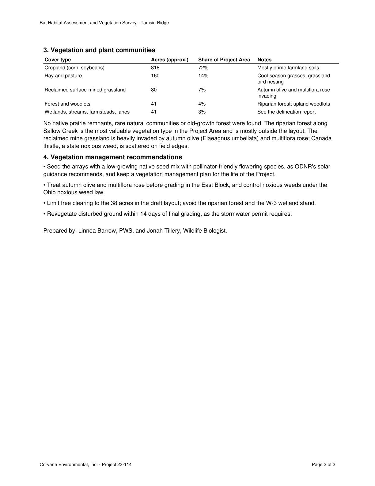
  1. Reclaimed mine grassland is heavily invaded by autumn olive and multiflora rose; Canada thistle, a state noxious weed, is scattered on field edges.Bat Habitat Assessment and Vegetation Survey - Tamsin Ridge Solar and Storage Project · Page 2Exact
  2. No native prairie remnants, rare natural communities or old-growth forest were found.Bat Habitat Assessment and Vegetation Survey - Tamsin Ridge Solar and Storage Project · Page 2Exact
  3. Parts of the East Block woodlots were not accessible because of reclamation spoil and dense autumn olive.Phase I Environmental Site Assessment - Tamsin Ridge Solar and Storage Project · Page 3Exact
  4. Service recommends scheduling vegetation clearing outside the primary nesting season where possible.Official Species List - Tamsin Ridge Solar and Storage · Page 1Exact
  5. The Division recommends wildlife-permeable fencing, native pollinator-friendly seed mixes, and mowing outside the grassland bird nesting season (April 15 to July 31).ODNR Environmental Review - Tamsin Ridge Solar and Storage Project (ODNR 23-0477) · Page 1Exact
  6. Cropland covers about 818 acres (72%) of the Project Area, mostly on prime farmland soils.Bat Habitat Assessment and Vegetation Survey - Tamsin Ridge Solar and Storage Project · Page 2Exact
  7. The conservation easement area along Sallow Creek on Parcel 9 is to remain in natural riparian cover.Commitment for Title Insurance No. ATA-23-0418 (Parcels 2, 5 and 9) · Page 2Exact
  8. Land cover is cropland and hay with woodlots along Sallow Creek and on reclaimed surface-mined ground in the East Block.Tamsin Ridge Solar and Storage Project - Project Description · Page 1Exact
  9. About 80 acres (7%) of the Project Area is reclaimed surface-mined grassland.Bat Habitat Assessment and Vegetation Survey - Tamsin Ridge Solar and Storage Project · Page 2Exact
  10. Recommendation to avoid the riparian forest and the W-3 wetland stand when limiting tree clearing to 38 acres.Bat Habitat Assessment and Vegetation Survey - Tamsin Ridge Solar and Storage Project · Page 2Exact
  11. Forest covers about 41 acres and the draft layout clears about 38 acres of trees.Bat Habitat Assessment and Vegetation Survey - Tamsin Ridge Solar and Storage Project · Page 1Exact
  12. Seed arrays with a low-growing native pollinator-friendly mix and keep a vegetation management plan for the project life.Bat Habitat Assessment and Vegetation Survey - Tamsin Ridge Solar and Storage Project · Page 2Exact
  13. Riparian forest lines most of Sallow Creek's length.Wetland and Stream Delineation Report - Tamsin Ridge Solar and Storage Project · Page 2Exact
  14. Cut trees only from October 1 to March 31, leave riparian forest within 100 feet of Sallow Creek standing, and survey first if summer clearing is needed.Bat Habitat Assessment and Vegetation Survey - Tamsin Ridge Solar and Storage Project · Page 1Exact

Bat Habitat Assessment and Vegetation Survey - Tamsin Ridge Solar and Storage Project

C-08f3573546 · Page 2 of 2 · DR-0007

Open the claim, C-08f3573546

Reclaimed mine grassland is heavily invaded by autumn olive and multiflora rose; Canada thistle, a state noxious weed, is scattered on field edges.

Quote check Exact · Placed normalised · The quote matches the page once line breaks, hyphenation, case and punctuation are set aside, as the engine's matcher compares text. The marked words are the page's own. · Read as native

Bat Habitat Assessment and Vegetation Survey - Tamsin Ridge 3. Vegetation and plant communities Cover type Acres (approx.) Share of Project Area Notes Cropland (corn, soybeans) 818 72% Mostly prime farmland soils Hay and pasture 160 14% Cool-season grasses; grassland bird nesting Reclaimed surface-mined grassland 80 7% Autumn olive and multiflora rose invading Forest and woodlots 41 4% Riparian forest; upland woodlots Wetlands, streams, farmsteads, lanes 41 3% See the delineation report No native prairie remnants, rare natural communities or old-growth forest were found. The riparian forest along Sallow Creek is the most valuable vegetation type in the Project Area and is mostly outside the layout. The reclaimed mine grassland is heavily invaded by autumn olive (Elaeagnus umbellata) and multiflora rose; Quote starts. Canada thistle, a state noxious weed, is scattered on field edges. Quote ends. 4. Vegetation management recommendations • Seed the arrays with a low-growing native seed mix with pollinator-friendly flowering species, as ODNR's solar guidance recommends, and keep a vegetation management plan for the life of the Project. • Treat autumn olive and multiflora rose before grading in the East Block, and control noxious weeds under the Ohio noxious weed law. • Limit tree clearing to the 38 acres in the draft layout; avoid the riparian forest and the W-3 wetland stand. • Revegetate disturbed ground within 14 days of final grading, as the stormwater permit requires. Prepared by: Linnea Barrow, PWS, and Jonah Tillery, Wildlife Biologist. Corvane Environmental, Inc. - Project 23-114 Page 2 of 2

The outline marks where the quote begins on the page.

Page 2 of Bat Habitat Assessment and Vegetation Survey - Tamsin Ridge Solar and Storage Project
  1. C-08f3573546

    Reclaimed mine grassland is heavily invaded by autumn olive and multiflora rose; Canada thistle, a state noxious weed, is scattered on field edges.

    Quoted from page 2
    Canada thistle, a state noxious weed, is scattered on field edges.

    Bat Habitat Assessment and Vegetation Survey - Tamsin Ridge Solar and Storage Project · DR-0007 · Page 2 · 2023-06-20

    Source field_study · Claim type presence · Polarity presence · Confidence high · Quote check exact, 100 of 100

  2. C-100c2c5e80

    No native prairie remnants, rare natural communities or old-growth forest were found.

    Quoted from page 2
    No native prairie remnants, rare natural communities or old-growth forest were found.

    Bat Habitat Assessment and Vegetation Survey - Tamsin Ridge Solar and Storage Project · DR-0007 · Page 2 · 2023-06-20

    Source field_study · Claim type absence · Polarity absence · Confidence high · Quote check exact, 100 of 100

  3. C-421d66e93e

    Parts of the East Block woodlots were not accessible because of reclamation spoil and dense autumn olive.

    Quoted from page 3
    Parts of the woodlots in the East Block were not accessible because of reclamation spoil and dense autumn olive.

    Phase I Environmental Site Assessment - Tamsin Ridge Solar and Storage Project · DR-0012 · Page 3 · 2023-01-27

    Source consultant_memo · Claim type data_gap · Polarity neutral · Confidence high · Quote check exact, 100 of 100

    Cited by EN-04 · Filed under EC-03, EN-04

  4. C-4e22698f2d

    Service recommends scheduling vegetation clearing outside the primary nesting season where possible.

    Quoted from page 1
    schedule vegetation clearing outside the primary nesting season where possible.

    Official Species List - Tamsin Ridge Solar and Storage · DR-0010 · Page 1 · 2023-04-12

    Source agency_determination · Claim type recommendation · Polarity neutral · Confidence medium · Quote check exact, 100 of 100

    Cited by EC-02 · Filed under EC-02, EC-03

  5. C-557a6ccbbf

    The Division recommends wildlife-permeable fencing, native pollinator-friendly seed mixes, and mowing outside the grassland bird nesting season (April 15 to July 31).

    Quoted from page 1
    native pollinator-friendly seed mixes under and around the arrays, and mowing outside the grassland bird nesting season (April 15 to July 31).

    ODNR Environmental Review - Tamsin Ridge Solar and Storage Project (ODNR 23-0477) · DR-0011 · Page 1 · 2023-05-02

    Source agency_determination · Claim type recommendation · Polarity neutral · Confidence high · Quote check exact, 100 of 100

    Filed under EC-02, EC-03

  6. C-67ba142a5a

    Cropland covers about 818 acres (72%) of the Project Area, mostly on prime farmland soils.

    Quoted from page 2
    Cropland (corn, soybeans) 818 72% Mostly prime farmland soils

    Bat Habitat Assessment and Vegetation Survey - Tamsin Ridge Solar and Storage Project · DR-0007 · Page 2 · 2023-06-20

    Source field_study · Claim type extent · Polarity presence · Confidence medium · Quote check exact, 100 of 100

    Cited by EN-03 · Filed under EC-03, EN-03

  7. C-828699d893

    The conservation easement area along Sallow Creek on Parcel 9 is to remain in natural riparian cover.

    Quoted from page 2
    which is to remain in natural riparian cover.

    Commitment for Title Insurance No. ATA-23-0418 (Parcels 2, 5 and 9) · DR-0006 · Page 2 · 2023-04-18

    Source public_record · Claim type presence · Polarity presence · Confidence medium · Quote check exact, 100 of 100

    Cited by EN-07 · Filed under AQ-01, EC-03

  8. C-9d4b1ab8e4

    Land cover is cropland and hay with woodlots along Sallow Creek and on reclaimed surface-mined ground in the East Block.

    Quoted from page 1
    Land cover is cropland and hay with woodlots along Sallow Creek and on reclaimed surface-mined ground in the East Block.

    Tamsin Ridge Solar and Storage Project - Project Description · DR-0001 · Page 1 · 2023-06-12

    Source developer_document · Claim type presence · Polarity presence · Confidence high · Quote check exact, 100 of 100

    Cited by EC-01 · Filed under EC-03, EN-01, EN-03

  9. C-a6c169a2d9

    About 80 acres (7%) of the Project Area is reclaimed surface-mined grassland.

    Quoted from page 2
    Reclaimed surface-mined grassland 80 7%

    Bat Habitat Assessment and Vegetation Survey - Tamsin Ridge Solar and Storage Project · DR-0007 · Page 2 · 2023-06-20

    Source field_study · Claim type extent · Polarity presence · Confidence medium · Quote check exact, 100 of 100

    Cited by EC-02 · Filed under EC-03, EN-01

  10. C-b1fad0c404

    Recommendation to avoid the riparian forest and the W-3 wetland stand when limiting tree clearing to 38 acres.

    Quoted from page 2
    avoid the riparian forest and the W-3 wetland stand.

    Bat Habitat Assessment and Vegetation Survey - Tamsin Ridge Solar and Storage Project · DR-0007 · Page 2 · 2023-06-20

    Source consultant_memo · Claim type recommendation · Polarity presence · Confidence medium · Quote check exact, 100 of 100

    Filed under AQ-01, EC-03

  11. C-c0e63f6881

    Forest covers about 41 acres and the draft layout clears about 38 acres of trees.

    Quoted from page 1
    The draft layout clears about 38 acres of trees.

    Bat Habitat Assessment and Vegetation Survey - Tamsin Ridge Solar and Storage Project · DR-0007 · Page 1 · 2023-06-20

    Source field_study · Claim type extent · Polarity presence · Confidence medium · Quote check exact, 100 of 100

    Cited by EC-01, EC-02 · Filed under EC-01, EC-03

  12. C-d756845b5e

    Seed arrays with a low-growing native pollinator-friendly mix and keep a vegetation management plan for the project life.

    Quoted from page 2
    Seed the arrays with a low-growing native seed mix with pollinator-friendly flowering species

    Bat Habitat Assessment and Vegetation Survey - Tamsin Ridge Solar and Storage Project · DR-0007 · Page 2 · 2023-06-20

    Source consultant_memo · Claim type recommendation · Polarity neutral · Confidence high · Quote check exact, 100 of 100

  13. C-e10af45ca9

    Riparian forest lines most of Sallow Creek's length.

    Quoted from page 2
    Riparian forest lines most of its length.

    Wetland and Stream Delineation Report - Tamsin Ridge Solar and Storage Project · DR-0013 · Page 2 · 2023-05-22

    Source field_study · Claim type presence · Polarity presence · Confidence medium · Quote check exact, 100 of 100

    Cited by AQ-01 · Filed under AQ-01, EC-03

  14. C-ffa524ccb3

    Cut trees only from October 1 to March 31, leave riparian forest within 100 feet of Sallow Creek standing, and survey first if summer clearing is needed.

    Quoted from page 1
    cut trees only from October 1 to March 31, as ODNR and the Service recommend;

    Bat Habitat Assessment and Vegetation Survey - Tamsin Ridge Solar and Storage Project · DR-0007 · Page 1 · 2023-06-20

    Source consultant_memo · Claim type recommendation · Polarity neutral · Confidence high · Quote check exact, 100 of 100

    Cited by EC-01 · Filed under EC-01, EC-03

Requirements and permits

The requirements the assessor tied to this row, by level. Each quote from dated law is shown with its source.

No requirement is tied to this row.

Information requests

  • IR-6d6395d79e · Medium priority

    Provide the state natural heritage, forestry or wildlife agency review for the project area, or confirm none exists.

    Missing evidence
    State natural heritage, forestry or wildlife agency review
    Consequence
    Vegetation and Habitat is rated on partial evidence without it.
    Blocks the decision
    No
    Raised by
    completeness
  • IR-9dd4e3bc70 · Medium priority

    Provide the land cover or aerial imagery screen with clearing acreage for the project area, or confirm none exists.

    Missing evidence
    Land cover or aerial imagery screen with clearing acreage
    Consequence
    Vegetation and Habitat is rated on partial evidence without it.
    Blocks the decision
    No
    Raised by
    completeness
  • IR-8e1b822079 · Medium priority

    Provide the vegetation management, revegetation or invasive species plan for the project area, or confirm none exists.

    Missing evidence
    Vegetation management, revegetation or invasive species plan
    Consequence
    Vegetation and Habitat is rated on partial evidence without it.
    Blocks the decision
    No
    Raised by
    completeness

Next steps

  • Survey inaccessible East Block woodlots and measure forest by acre.
  • Refine layout to avoid riparian forest and the W-3 wetland stand and reduce clearing.
  • Prepare vegetation management and invasive species plan with native pollinator seed mix; clear trees October 1 to March 31.

Agencies

  • ODNR
  • USFWS
  • Carroll County

Cost and impact

Impact
C, S
Potential cost level
L-M
Why

About 38 acres of tree clearing within seasonal windows, plus a vegetation management plan, weed control and native seeding. No conversion approval is documented.

Impact: C = cost, S = schedule. Potential cost level: L, L-M, M, M-H, H (relative to a utility-scale solar budget).
Lumerian Labs 2026