Code computed the rating from the assessor's inputs:
extent=core, avoidable=partly -> 3
Set by the rule
Decision
Released with flags
The engine's reasons
Uncited absence claims to weigh: C-0af700a251(no record in the annex), C-2ff0fce9c8(no record in the annex), C-e9a687c1a0
Agencies not in the register or the evidence: Ohio EPA
Evidence state
Verified · field study or agency determination
Worst case
The same rule on the worst case gives no rating above the point.
Scenario
Phase II confirms brine and petroleum contamination across the proposed substation and BESS yard, needing agency-overseen remediation or relocation of the POI-adjacent facilities. Mine spoil on the East Block (not fully accessed) adds uncertainty.
Step still pending
Limited Phase II sampling at the Parcel 5 former tank battery
Phase I identifies REC 1, a suspected brine and petroleum release at the former tank battery on Parcel 5, with staining and stressed vegetation and no release report (C-fe98e6ae5a, C-b2025b56f8). Also a de minimis debris pile on Parcel 3 (C-02dc91fd44) and plugged wells (C-a7cffff0d2).
Substation and BESS siting on Parcel 5 is affected; avoidance would require resiting pending Phase II (C-46481122cf, C-94c3a5488e). The Parcel 3 debris is removable (C-1e239f0074). Other findings are closed or off site: the closed UST 0.8 mile south (C-fd18b09c16), the 2016 spill closed under ODNR oversight (C-b9b7baadd9).
A limited Phase II is recommended at the Parcel 5 tank battery and debris removal on Parcel 3 (C-46481122cf, C-1e239f0074). No regulated remediation is documented yet; no NPL, CERCLA or brownfield sites are in the search distances (C-5c2ccff84a).
The REC lies on the proposed substation and BESS yard, and foundations are recommended only after Phase II sampling (C-faf2f8bc21, C-94c3a5488e). Brine chlorides can also limit revegetation.
Phase I ESA identifies REC 1: suspected brine and petroleum release at former tank battery on Parcel 5, with staining and stressed vegetation, where the substation and BESS yard are proposed. Limited Phase II recommended. Parcel 3 debris pile de minimis. Closed UST 0.8 mile south. East Block mine spoil noted.
Critique
Verdict
upheld
Suggested direction for the rating
same
Summary
The assessment is largely supported by the cited quotes. Only minor issues: the Phase I is over 180 days old at the cut-off, the clean lien search is ignored, and a few labels and details ('REC 1', 'POI-adjacent', SPCC) are unsupported. The extent call is a judgment. Category 3 is reasonable.
Critic model
Luminol
Issues
Severity minor · Kind missing_next_step
The Phase I is dated 2023-01-27. By the 2023-08-01 cut-off it is more than 180 days old, so its time-sensitive components would need updating before it could support a purchase or financing reliance. The assessment doesn't mention this.
The lien next step ignores C-a898a65a41, which found no environmental liens in the public records searched. The AUL gap in C-061f16a94b is real, but the step should say that the lien search is already clean and that only the AUL and title review is outstanding.
The quotes don't contain the label 'REC 1' or the words 'Phase I ESA'. The worst case calls the facilities 'POI-adjacent', and no cited quote places the substation next to the POI. The SPCC point rests on a truncated quote. SPCC is a federal EPA program, and no federal agency is listed.
The present rationale leaves out the East Block mine spoil (C-8dc8e662ac) and the inaccessible woodlots (C-421d66e93e). They appear only in the worst case and comments. C-0497ffe228 (no acid seeps seen) weakens the concern. A survey of the inaccessible areas would settle it.
The extent 'core' call is a judgment. The REC stain is about 60 by 90 feet on a 780-acre buildable area, yet it lies where the substation is proposed. Phase II delineation would settle whether it is core or only local.
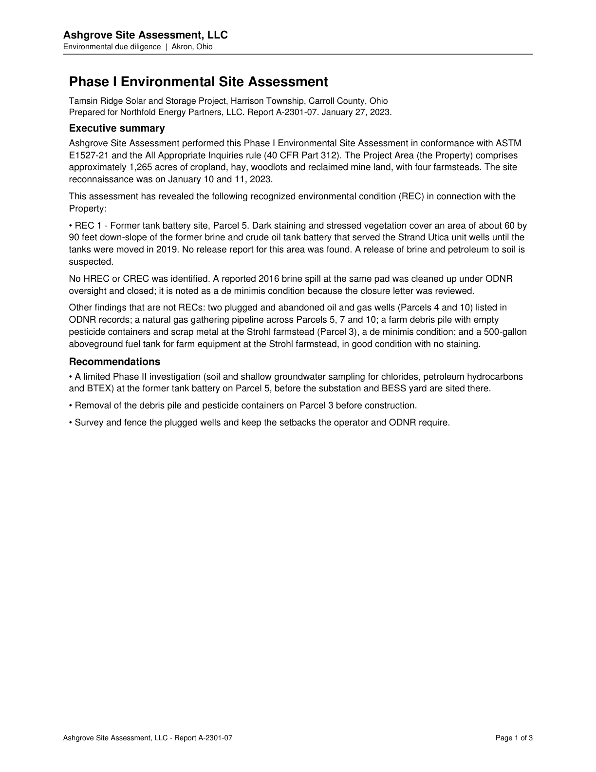
A farm debris pile with empty pesticide containers and scrap metal at the Strohl farmstead, Parcel 3, is a de minimis condition.
Quote check Exact · Placed normalised · The quote matches the page once line breaks, hyphenation, case and punctuation are set aside, as the engine's matcher compares text. The marked words are the page's own. · Read as native
Ashgrove Site Assessment, LLC
Environmental due diligence | Akron, Ohio
Phase I Environmental Site Assessment
Tamsin Ridge Solar and Storage Project, Harrison Township, Carroll County, Ohio
Prepared for Northfold Energy Partners, LLC. Report A-2301-07. January 27, 2023.
Executive summary
Ashgrove Site Assessment performed this Phase I Environmental Site Assessment in conformance with ASTM
E1527-21 and the All Appropriate Inquiries rule (40 CFR Part 312). The Project Area (the Property) comprises
approximately 1,265 acres of cropland, hay, woodlots and reclaimed mine land, with four farmsteads. The site
reconnaissance was on January 10 and 11, 2023.
This assessment has revealed the following recognized environmental condition (REC) in connection with the
Property:
• REC 1 - Former tank battery site, Parcel 5. Dark staining and stressed vegetation cover an area of about 60 by
90 feet down-slope of the former brine and crude oil tank battery that served the Strand Utica unit wells until the
tanks were moved in 2019. No release report for this area was found. A release of brine and petroleum to soil is
suspected.
No HREC or CREC was identified. A reported 2016 brine spill at the same pad was cleaned up under ODNR
oversight and closed; it is noted as a de minimis condition because the closure letter was reviewed.
Other findings that are not RECs: two plugged and abandoned oil and gas wells (Parcels 4 and 10) listed in
ODNR records; a natural gas gathering pipeline across Parcels 5, 7 and 10; Quote starts. a farm debris pile with empty
pesticide containers and scrap metal at the Strohl farmstead (Parcel 3), a de minimis condition Quote ends.; and a 500-gallon
aboveground fuel tank for farm equipment at the Strohl farmstead, in good condition with no staining.
Recommendations
• A limited Phase II investigation (soil and shallow groundwater sampling for chlorides, petroleum hydrocarbons
and BTEX) at the former tank battery on Parcel 5, before the substation and BESS yard are sited there.
• Removal of the debris pile and pesticide containers on Parcel 3 before construction.
• Survey and fence the plugged wells and keep the setbacks the operator and ODNR require.
Ashgrove Site Assessment, LLC - Report A-2301-07 Page 1 of 3
The outline marks where the quote begins on the page.
C-02dc91fd44
A farm debris pile with empty pesticide containers and scrap metal at the Strohl farmstead, Parcel 3, is a de minimis condition.
Quoted from page 1
a farm debris pile with empty
pesticide containers and scrap metal at the Strohl farmstead (Parcel 3), a de minimis condition
A limited Phase II with soil and shallow groundwater sampling is recommended at the Parcel 5 former tank battery before the substation and BESS yard are sited there.
Quoted from page 1
A limited Phase II investigation (soil and shallow groundwater sampling for chlorides, petroleum hydrocarbons
and BTEX) at the former tank battery on Parcel 5
One closed leaking UST case is 0.8 mile south at a former filling station on State Route 43, down-gradient, closed with no further action.
Quoted from page 2
One closed leaking underground storage tank (UST) case is
0.8 mile south at a former filling station on State Route 43; it is down-gradient and closed with no further action.
The requirements the assessor tied to this row, by level. Each quote from dated law is shown with its source.
No requirement is tied to this row.
Information requests
IR-6b1aae03de · High priority
Provide the regulatory database screen (federal epa and state contaminated-site, release and tank lists) for the project area, or confirm none exists.
Missing evidence
Regulatory database screen (federal EPA and state contaminated-site, release and tank lists)
Consequence
Environmental Contamination is rated on partial evidence without it.
Blocks the decision
No
Raised by
completeness
Next steps
Complete limited Phase II at Parcel 5 tank battery before fixing substation and BESS layout.
Remove Parcel 3 debris and pesticide containers before construction.
Obtain environmental lien and AUL search once title commitments are issued.
Agencies
Ohio EPA
ODNR
Cost and impact
Impact
C, S
Potential cost level
M
Why
Phase II sampling, debris removal and possible soil handling or resiting at the substation and BESS yard; the SPCC plan for the transformer is routine (C-e571f3a9eb). Cost would rise if remediation is required.
Impact: C = cost, S = schedule. Potential cost level: L, L-M, M, M-H, H (relative to a utility-scale solar budget).
Comments
Phase I ESA identifies REC 1: suspected brine and petroleum release at former tank battery on Parcel 5, with staining and stressed vegetation, where the substation and BESS yard are proposed. Limited Phase II recommended. Parcel 3 debris pile de minimis. Closed UST 0.8 mile south. East Block mine spoil noted.