Code computed the rating from the assessor's inputs:
extent=core, avoidable=partly -> 3
Set by the rule
Decision
Released with flags
The engine's reasons
Uncited absence claims to weigh: C-f77ef514cf(no record in the annex)
Numbers not found in cited evidence: 31.0
Agencies not in the register or the evidence: Carroll County
Evidence state
Reported · desktop, consultant or developer record
Worst case
The same rule on the worst case gives no rating above the point.
Scenario
The Parcel 11 trustee holds out with no condemnation available, and Brenwick will not waive its second pad, removing array area and forcing a road right-of-way collection route and access redesign.
Step still pending
Parcel 11 negotiation and Brenwick accommodation agreement
Core and partly-avoidable inputs are reasonable, and Parcel 11 and Brenwick are well supported. Weakened by unsupported specifics: the 1.3-mile route, the 1912 date and no-liability coal wording, and 'well above appraisal'. The agencies are thin. Category 3 looks right.
Revised once after the first critique. Rating unchanged.
The five inputs
Present: yes
Site control is through option-to-lease agreements on 12 of 14 parcels plus a recorded collection line easement on Parcel 7 (C-04c97c05c7, C-1f788fe1e5), so land rights and third-party rights on title are present.
Parcel 11 is not under any agreement and the planned collection route and East Block access road cross it (C-3ce7653be3, C-cd08e1f358, C-489cabb421). The Brenwick lessee's planned second pad on Parcel 2 overlaps about 9 acres of the array layout and its accommodation agreement is unsigned (C-7d33945087, C-9099731d6e). Control of buildable area is therefore incomplete. Mitigating: title found no other severed minerals beyond coal and oil and gas (C-9dcc852809) and no setback waivers are needed (C-2a27cb9782), so the issues are concentrated.
Without Parcel 11 the collection line would follow the Linnet Road right-of-way, which needs a county right-of-way permit (C-7dce4e6e67, C-4c5acf992f). East Block access also crosses Parcel 11 and no alternative is documented (C-489cabb421). The Brenwick pad overlap could remove array area unless an accommodation agreement is signed (C-7d33945087, C-faaf963eae). The Parcel 9 SNDA is a routine step (C-2a9dd4b09a). The Parcel 9 coal severance is a constraint, but the coal was largely mined out (C-343e9b9832).
The Parcel 11 trustee has declined the standard option twice, which is holdout behaviour, and the Project has no condemnation power (C-61e6db1965, C-ebcacfde9b). The Brenwick mineral lessee holds surface-use rights and the accommodation agreement is unsigned (C-dcf3900993, C-9099731d6e). The other items (memoranda of lease, SNDA, pipeline crossing agreement) are routine (C-b22b20654d, C-2a9dd4b09a, C-d257ecfe8e).
An uncontrolled parcel is needed for the collection route and East Block access (C-cd08e1f358, C-489cabb421). A mineral lessee with surface rights has a planned pad overlapping about 9 acres of array (C-7d33945087). The Parcel 9 coal reservation carries a right to mine (C-579694c789). The Parcel 9 conservation easement is rated under EN-07.
Options cover 12 of the 14 parcels (1,063.4 acres). Parcel 11 (31.0 acres) is unleased, needed for collection and East Block access; its trustee declined the option twice. Brenwick accommodation agreement is unsigned; its second pad overlaps about 9 acres of array. Parcel 9 SNDA and coal reservation remain open.
Critique
Verdict
upheld
Suggested direction for the rating
same
Summary
Assessment is largely supported by the cited quotes. Only minor issues: an unsupported Parcel 9 conservation easement mention, the unexplained 14th parcel, and a judgment-call extent. The uncited assignment clause does not weaken it.
Critic model
Luminol
Issues
Severity minor · Kind unsupported_statement
The impact_likely rationale mentions a Parcel 9 conservation easement rated under EN-07. No cited claim mentions it. Cite a claim or drop the sentence.
Options cover 12 of 14 parcels and only Parcel 11 is named as uncontrolled. The 14th parcel's status is never explained. Parcel 7 may be easement-only. Confirm it and add option expiry dates against the December 2026 COD.
Extent 'core' is a judgment call. Parcel 11 is 31 acres and the pad overlap is about 9 acres, against 780 buildable acres. It rests on Parcel 11 being essential for the collection route and access. A confirmed Linnet Road route and an East Block access alternative would settle it. 'Holdout behaviour' is also an inference from a truncated quote.
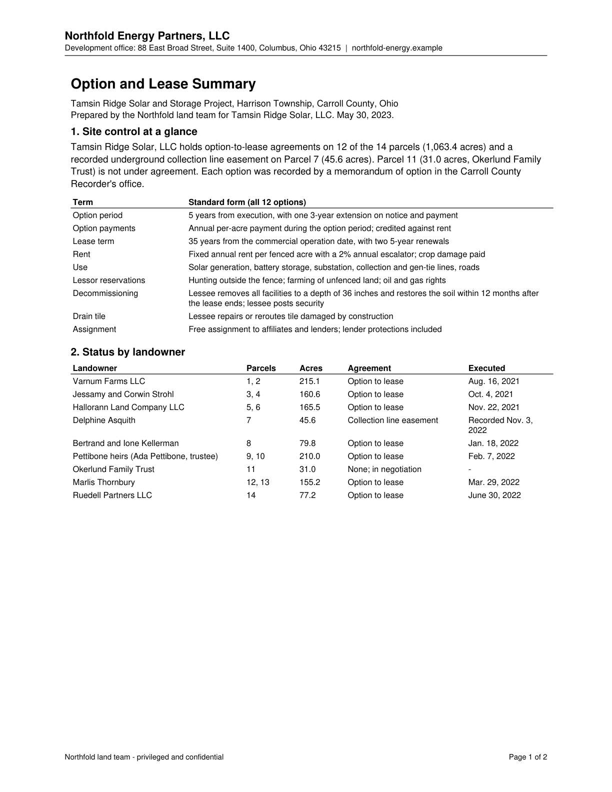
Site control is through option-to-lease agreements on 12 of 14 parcels (1,063.4 acres) plus a recorded collection line easement on Parcel 7.
Quote check Exact · Placed verbatim · The quote occurs on the page exactly as written. · Read as native
Northfold Energy Partners, LLC
Development office: 88 East Broad Street, Suite 1400, Columbus, Ohio 43215 | northfold-energy.example
Option and Lease Summary
Tamsin Ridge Solar and Storage Project, Harrison Township, Carroll County, Ohio
Prepared by the Northfold land team for Tamsin Ridge Solar, LLC. May 30, 2023.
1. Site control at a glance
Tamsin Ridge Solar, LLC Quote starts. holds option-to-lease agreements on 12 of the 14 parcels (1,063.4 acres) and a Quote ends.
recorded underground collection line easement on Parcel 7 (45.6 acres). Parcel 11 (31.0 acres, Okerlund Family
Trust) is not under agreement. Each option was recorded by a memorandum of option in the Carroll County
Recorder's office.
Term Standard form (all 12 options)
Option period 5 years from execution, with one 3-year extension on notice and payment
Option payments Annual per-acre payment during the option period; credited against rent
Lease term 35 years from the commercial operation date, with two 5-year renewals
Rent Fixed annual rent per fenced acre with a 2% annual escalator; crop damage paid
Use Solar generation, battery storage, substation, collection and gen-tie lines, roads
Lessor reservations Hunting outside the fence; farming of unfenced land; oil and gas rights
Decommissioning Lessee removes all facilities to a depth of 36 inches and restores the soil within 12 months after
the lease ends; lessee posts security
Drain tile Lessee repairs or reroutes tile damaged by construction
Assignment Free assignment to affiliates and lenders; lender protections included
2. Status by landowner
Landowner Parcels Acres Agreement Executed
Varnum Farms LLC 1, 2 215.1 Option to lease Aug. 16, 2021
Jessamy and Corwin Strohl 3, 4 160.6 Option to lease Oct. 4, 2021
Hallorann Land Company LLC 5, 6 165.5 Option to lease Nov. 22, 2021
Delphine Asquith 7 45.6 Collection line easement Recorded Nov. 3,
2022
Bertrand and Ione Kellerman 8 79.8 Option to lease Jan. 18, 2022
Pettibone heirs (Ada Pettibone, trustee) 9, 10 210.0 Option to lease Feb. 7, 2022
Okerlund Family Trust 11 31.0 None; in negotiation -
Marlis Thornbury 12, 13 155.2 Option to lease Mar. 29, 2022
Ruedell Partners LLC 14 77.2 Option to lease June 30, 2022
Northfold land team - privileged and confidential Page 1 of 2
The outline marks where the quote begins on the page.
C-04c97c05c7
Site control is through option-to-lease agreements on 12 of 14 parcels (1,063.4 acres) plus a recorded collection line easement on Parcel 7.
Quoted from page 1
holds option-to-lease agreements on 12 of the 14 parcels (1,063.4 acres) and a
The easement crosses the Calder Gathering Company natural gas gathering line, requiring the grantee to obtain a written crossing agreement and keep required clearance.
Quoted from page 1
Grantee will obtain that company's written crossing agreement and keep the clearance it requires.
An accommodation agreement or partial surface release from Brenwick Exploration is required for oil and gas lease areas to be occupied by the solar facility; otherwise no affirmative coverage.
Quoted from page 1
Record an accommodation agreement, or a partial release of surface rights, from Brenwick Exploration, LLC
The requirements the assessor tied to this row, by level. Each quote from dated law is shown with its source.
No requirement is tied to this row.
Information requests
IR-7d328a6772 · High priority
Provide the mineral ownership or surface-use review for the project area, or confirm none exists.
Missing evidence
Mineral ownership or surface-use review
Consequence
Site Control and Land Rights is rated on partial evidence without it.
Blocks the decision
No
Raised by
completeness
IR-5f0015e952 · High priority
Provide the parcel control table or site control summary for the project area, or confirm none exists.
Missing evidence
Parcel control table or site control summary
Consequence
Site Control and Land Rights is rated on partial evidence without it.
Blocks the decision
No
Raised by
completeness
Next steps
Resolve Parcel 11 by negotiation, or confirm the Linnet Road alternative (county right-of-way permit) and East Block access.
Execute the Brenwick accommodation agreement, the Parcel 9 SNDA and memoranda of lease.
Build a parcel control table with option expiry dates against the COD schedule.
Agencies
Carroll County
Cost and impact
Impact
C, S
Potential cost level
M-H
Why
Essential Parcel 11 is missing and its trustee has declined the option twice. A minerals accommodation, SNDA and possible collection rerouting are pending.
Impact: C = cost, S = schedule. Potential cost level: L, L-M, M, M-H, H (relative to a utility-scale solar budget).
Comments
Options cover 12 of the 14 parcels (1,063.4 acres). Parcel 11 (31.0 acres) is unleased, needed for collection and East Block access; its trustee declined the option twice. Brenwick accommodation agreement is unsigned; its second pad overlaps about 9 acres of array. Parcel 9 SNDA and coal reservation remain open.