Construction will disturb more than one acre, so OHC000006 coverage with an SWP3 and post-construction treatment applies (C-4bf6e9a178, C-09073c6534; OH-SWM).
Soils are mostly hydrologic groups C and D (C-55cbc4b507), but slope distribution across the buildable area is not documented (no desktop hydrology in data room). Sallow Creek is not impaired and has no TMDL (C-846e2b0e13), so no receiving-water limit makes it core. About 96 of 780 fenced acres will be graded (C-4c4d92f167). Core cannot be established.
General-permit controls with water quality volume treatment, panel disconnection under Ohio EPA solar guidance and sub-threshold basins (about 9 acre-feet, embankments no higher than 6 feet) appear to meet requirements (C-09073c6534, C-ce17cc3949, C-ebc49abde3). No receiving-water limit identified (C-846e2b0e13).
General permit OHC000006 with SWP3 and Notice of Intent; no individual permit or TMDL-specific limit indicated; ODNR dam permit not triggered by basin sizes (C-4bf6e9a178, C-ebc49abde3, C-846e2b0e13).
Runoff-prone C/D soils with moderate to high runoff potential and planned stormwater basins show post-construction controls beyond disconnection alone (C-55cbc4b507, C-ebc49abde3). Residents raised runoff concerns (C-a82aff7176). Slope share is undocumented, so this rests on soils and basins rather than steep slopes.
Construction stormwater coverage under OHC000006 required; about 96 acres of the 780-acre fenced area will be graded. Soils are mostly hydrologic groups C and D with moderate to high runoff. Sallow Creek is not impaired and has no TMDL. Basins fall below ODNR dam thresholds. Slope data not provided.
Critique
Verdict
upheld
Suggested direction for the rating
same
Summary
Core inputs follow the cited evidence: general permit applies, extent unknown, basins below ODNR thresholds, Sallow Creek unimpaired. Only minor problems remain: an unsupported 14-day revegetation cost note, an unseen worst-case claim ID, agency list padding, and missing next steps.
Critic model
Luminol
Issues
Severity minor · Kind unsupported_statement
Cost rationale cites '14-day revegetation'. No cited quote supports this. Ohio EPA solar guidance is also named as a source for panel disconnection, but only the requirement description supports it.
The worst case cites C-682e211cfb, which is not in the cited claims shown. The steep-slope scenario rests on no provided claim, though the pending desktop slope analysis is a real step.
ODNR is listed as an agency although the assessment finds the dam permit is not triggered. The Carroll County Engineer rests only on the culvert requirement, not on stormwater evidence.
The next steps omit that OHC000006 coverage is not effective until Ohio EPA's approval letter is received. They also omit confirming receiving waters other than Sallow Creek. The resident flooding concern along Sallow Creek is not addressed, for example by a downstream or floodplain check.
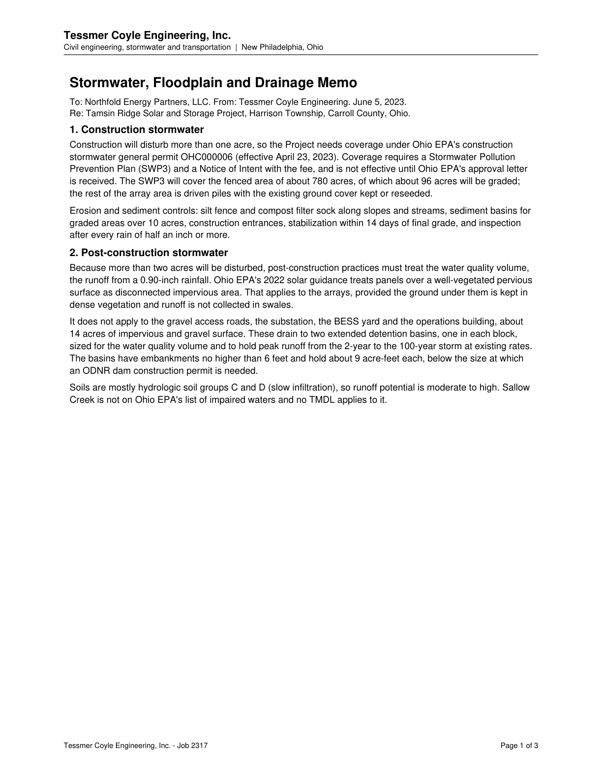
Post-construction practices must treat the water quality volume (0.90-inch rainfall runoff) because more than two acres will be disturbed.
Quote check Exact · Placed verbatim · The quote occurs on the page exactly as written. · Read as native
Tessmer Coyle Engineering, Inc.
Civil engineering, stormwater and transportation | New Philadelphia, Ohio
Stormwater, Floodplain and Drainage Memo
To: Northfold Energy Partners, LLC. From: Tessmer Coyle Engineering. June 5, 2023.
Re: Tamsin Ridge Solar and Storage Project, Harrison Township, Carroll County, Ohio.
1. Construction stormwater
Construction will disturb more than one acre, so the Project needs coverage under Ohio EPA's construction
stormwater general permit OHC000006 (effective April 23, 2023). Coverage requires a Stormwater Pollution
Prevention Plan (SWP3) and a Notice of Intent with the fee, and is not effective until Ohio EPA's approval letter
is received. The SWP3 will cover the fenced area of about 780 acres, of which about 96 acres will be graded;
the rest of the array area is driven piles with the existing ground cover kept or reseeded.
Erosion and sediment controls: silt fence and compost filter sock along slopes and streams, sediment basins for
graded areas over 10 acres, construction entrances, stabilization within 14 days of final grade, and inspection
after every rain of half an inch or more.
2. Post-construction stormwater
Quote starts. Because more than two acres will be disturbed, post-construction practices must treat the water quality volume, Quote ends.
the runoff from a 0.90-inch rainfall. Ohio EPA's 2022 solar guidance treats panels over a well-vegetated pervious
surface as disconnected impervious area. That applies to the arrays, provided the ground under them is kept in
dense vegetation and runoff is not collected in swales.
It does not apply to the gravel access roads, the substation, the BESS yard and the operations building, about
14 acres of impervious and gravel surface. These drain to two extended detention basins, one in each block,
sized for the water quality volume and to hold peak runoff from the 2-year to the 100-year storm at existing rates.
The basins have embankments no higher than 6 feet and hold about 9 acre-feet each, below the size at which
an ODNR dam construction permit is needed.
Soils are mostly hydrologic soil groups C and D (slow infiltration), so runoff potential is moderate to high. Sallow
Creek is not on Ohio EPA's list of impaired waters and no TMDL applies to it.
Tessmer Coyle Engineering, Inc. - Job 2317 Page 1 of 3
The outline marks where the quote begins on the page.
C-09073c6534
Post-construction practices must treat the water quality volume (0.90-inch rainfall runoff) because more than two acres will be disturbed.
Quoted from page 1
Because more than two acres will be disturbed, post-construction practices must treat the water quality volume,
Ohio EPA's 2022 solar guidance treats panels over well-vegetated pervious surface as disconnected impervious area, provided dense vegetation is kept and runoff is not collected in swales.
Quoted from page 1
surface as disconnected impervious area. That applies to the arrays, provided the ground under them is kept in
The requirements the assessor tied to this row, by level. Each quote from dated law is shown with its source.
State
Coverage under the construction stormwater general permit OHC000006 (Notice of Intent, SWP3 and post-construction controls)
OH-SWM · Ohio Environmental Protection Agency (Ohio EPA), Division of Surface Water
Applicability
Required
Instrument
ORC 6111.03 and 6111.04; NPDES general permit OHC000006 (effective 2023-04-23)
Trigger
Construction that disturbs one or more acres of land, or less than one acre that is part of a larger common plan of development or sale that will ultimately disturb one or more acres.
Description
ORC Chapter 6111 authorizes Ohio to take part in the national pollutant discharge elimination system; Ohio EPA covers construction stormwater through general permit OHC000006. Construction disturbing one or more acres, including smaller work in a larger common plan of development or sale, is eligible for coverage. To obtain it, the operator prepares a Stormwater Pollution Prevention Plan (SWP3) and files a Notice of Intent with the fee; coverage is not effective until Ohio EPA's approval letter is received. At two or more acres of disturbance, post-construction practices must treat the water quality volume, the runoff from a 0.90-inch rainfall. For ground-mounted PV arrays, Ohio EPA's solar guidance (2022-04) says impervious surface disconnection over vegetated pervious ground may be an effective approach, but it cannot manage that volume over gravel or other hard surfaces, where piling disrupts sheet flow, or where runoff is collected in swales, ditches or storm sewers.
Typical timeline
Notice of Intent, SWP3 and fee at least 21 days before construction starts, or 45 days in the Big Darby Creek watershed and portions of the Olentangy watershed, where the SWP3 is attached to the NOI. Coverage is not effective until Ohio EPA's approval letter is received.
Version of the law on the cut-off
General permit OHC000006, effective 2023-04-23 (the library text)
As of the cut-off
As of the cut-off: Ohio EPA's construction stormwater general permit OHC000006 took effect (it expires 2028-04-22), replacing OHC000005, which was in force from 2018-04-23 to 2023-04-22. (2023-04-23)
This chapter authorizes the state to participate in any national sludge management program and the national pollutant discharge elimination system, to administer and enforce the publicly owned treatment works pretreatment program, and to issue permits for the discharge of dredged or fill materials, in accordance with the Federal Water Pollution Control Act.
Source ORC 6111 water pollution isolated wetlands 401 · page 15 · version 2023-08-01
In force from 2019-10-17 to 2026-10-03, section 6111.03
6111.03: version effective 2019-10-17, still the current version when the page map was checked (2026-10-03)
May be cited on the cut-off date.
Quoted from the law, page 3
Construction activities disturbing one or more acres of total land or will disturb less than one acre of land but are part of a larger common plan of development or sale that will ultimately disturb one or more acres of land are eligible for coverage under this permit.
Source OEPA NPDES Construction Stormwater General Permit OHC000006 final · page 3 · version 2023-04-23
May be cited on the cut-off date.
Quoted from the law, page 7
If more than one operator, as defined in Part VII of this general permit, will be engaged at a site, each operator shall seek coverage under this general permit prior to engaging in construction activities. Coverage under this permit is not effective until an approval letter granting coverage from the director of Ohio EPA is received by the applicant.
Source OEPA NPDES Construction Stormwater General Permit OHC000006 final · page 7 · version 2023-04-23
May be cited on the cut-off date.
Quoted from the law, page 1
develop a stormwater pollution prevention plan (SWP3) and submit a complete Notice of Intent (NOI) form and appropriate application fee prior to the commencement of construction activity. These shall occur at least 45 days prior for sites within the Big Darby Creek and portions of the Olentangy River watersheds (including attaching SWP3 to NOI); and at least 21 days elsewhere.
Source OEPA OHC000006 Fact Sheet final · page 1 · version 2023-04
May be cited on the cut-off date.
Quoted from the law, page 20
For all construction activities that will disturb two or more acres of land or will disturb less than two acres that are part of a larger common plan of development or sale which will disturb two or more acres of land, the post construction BMP(s) chosen shall be able to manage stormwater runoff
Source OEPA NPDES Construction Stormwater General Permit OHC000006 final · page 20 · version 2023-04-23
May be cited on the cut-off date.
Quoted from the law, page 21
The BMP(s) chosen must be sized to treat the water quality volume (WQv) and ensure compliance with Ohio’s Water Quality Standards in OAC Chapter 3745-1. The WQv shall be equivalent to the volume of runoff from a 0.90-inch rainfall
Source OEPA NPDES Construction Stormwater General Permit OHC000006 final · page 21 · version 2023-04-23
May be cited on the cut-off date.
Quoted from the law, page 1
Large arrays of ground-mounted, elevated solar or photovoltaic (PV) panels are often installed with vegetated pervious ground around, between, and under them. In this case, impervious surface disconnection may be an effective approach to managing post-construction stormwater runoff shed from the PV panels.
Source OEPA Guidance Post Construction Stormwater Management for Solar Panel Fields · page 1 · version 2022-04
May be cited on the cut-off date.
Quoted from the law, page 2
Impervious surface disconnection cannot be used to manage the WQv for PV panels installed over gravel or other hard surfaces, where structural support (piling) will disrupt sheet flow, or where stormwater is to be collected in swales, ditches, or storm sewers.
Source OEPA Guidance Post Construction Stormwater Management for Solar Panel Fields · page 2 · version 2022-04
May be cited on the cut-off date.
ODNR construction permit for a dam, including a stormwater pond embankment, above the statutory exemption thresholds
OH-DAM · Ohio Department of Natural Resources (ODNR), Division of Water Resources
Applicability
Conditional
Instrument
ORC 1521.06 and 1521.062; OAC Chapter 1501:21 (dam safety rules)
Trigger
A pond embankment, such as a stormwater basin, or other dam that is not exempt by size: ten feet or higher storing more than 15 acre-feet, or over six feet high storing more than 50 acre-feet.
Description
No dam may be built to store, conserve or retard water, or for any other purpose, without a construction permit. A permit is not required for a dam under ten feet high that stores 50 acre-feet or less, for a dam of 15 acre-feet or less, or for a dam six feet or less in height, as the chief determines; in effect, a permit is needed for a dam ten feet or higher that stores more than 15 acre-feet, or one over six feet high that stores more than 50 acre-feet. Ohio's Rainwater and Land Development manual says ponds with dams are regulated under the dam safety rules (Chapter 1501:21). The application needs engineer-prepared plans with a cost estimate, a filing fee and a bond; an engineer inspects the construction, and dams are later inspected periodically.
Typical timeline
The chief issues or denies the construction permit within 30 days of receiving the application, fee and bond or other security; dams are then inspected at intervals set by the chief that do not exceed five years.
No dam may be constructed for the purpose of storing, conserving, or retarding water, or for any other purpose, nor shall any levee be constructed for the purpose of diverting or retaining flood water, unless the person or governmental agency desiring the construction has a construction permit for the dam or levee
In force from 2021-09-30 to 2026-10-03, section 1521.06
1521.06: version effective 2021-09-30, still the current version when the page map was checked (2026-10-03)
May be cited on the cut-off date.
Quoted from the law, page 1
(1) A dam that is or will be less than ten feet in height and that has or will have a storage capacity of not more than fifty acre-feet at the elevation of the top of the dam, as determined by the chief.
In force from 2021-09-30 to 2026-10-03, section 1521.06
1521.06: version effective 2021-09-30, still the current version when the page map was checked (2026-10-03)
May be cited on the cut-off date.
Quoted from the law, page 1
(2) A dam, regardless of height, that has or will have a storage capacity of not more than fifteen acre-
feet at the elevation of the top of the dam, as determined by the chief; (3) A dam, regardless of storage capacity, that is or will be six feet or less in height, as determined by the chief;
In force from 2021-09-30 to 2026-10-03, section 1521.06
1521.06: version effective 2021-09-30, still the current version when the page map was checked (2026-10-03)
May be cited on the cut-off date.
Quoted from the law, page 2
including a detailed cost estimate, for the proposed construction, prepared by a registered professional engineer, together with any filing fee specified by rules adopted by the chief in accordance with division (I) of this section and the bond or other security required by section 1521.061 of the Revised Code, shall be filed with the chief.
In force from 2021-09-30 to 2026-10-03, section 1521.06
1521.06: version effective 2021-09-30, still the current version when the page map was checked (2026-10-03)
May be cited on the cut-off date.
Quoted from the law, page 2
The chief shall, within thirty days from the date of the receipt of the application, fee, and bond or other security, issue or deny a construction permit for the construction or may issue a construction permit conditioned upon the making of such changes in the plans and specifications for the construction as the chief considers advisable
In force from 2021-09-30 to 2026-10-03, section 1521.06
1521.06: version effective 2021-09-30, still the current version when the page map was checked (2026-10-03)
May be cited on the cut-off date.
Quoted from the law, page 3
(E) A registered professional engineer shall inspect the construction for which the permit was issued during all phases of construction and shall furnish to the chief such regular reports of the engineer's inspections as the chief may require.
In force from 2019-10-17 to 2026-10-03, section 1521.062
1521.062: version effective 2019-10-17, still the current version when the page map was checked (2026-10-03)
May be cited on the cut-off date.
Quoted from the law, page 77
Ponds with dams are regulated under the Ohio Revised Code 1501: 21 Dam Safety Administrative Rules. A dam is exempt from the state’s authority (ORC Section 1521.062) if it is 6 feet or less in height regardless of total storage; less than 10 feet in height with not more than 50 acre-feet of storage,
Source Rainwater and Land Development manual chapters in force · page 77 · version 2023-08-01
Comments
Construction stormwater coverage under OHC000006 required; about 96 acres of the 780-acre fenced area will be graded. Soils are mostly hydrologic groups C and D with moderate to high runoff. Sallow Creek is not impaired and has no TMDL. Basins fall below ODNR dam thresholds. Slope data not provided.