Skip to content

AQ-02 · Matrix · Aquatic Resources

Rating
3Resource is present, likely difficult to address
Why
Core of the site; partly avoidable
Worst case
Not above the rating
Evidence
Verified
Cited claims
16
Requirements
2
Requests
0

Rating

3Resource is present, likely difficult to address

The engine shows this rating as 3

The rule

Code computed the rating from the assessor's inputs:

extent=core, avoidable=partly -> 3

Set by the rule

Decision
Released with flags
The engine's reasons
  • Independent assessments split on the category (5 samples: {'3': 3, '2': 2})
Evidence state
Verified · field study or agency determination

Worst case

The same rule on the worst case gives no rating above the point.

Scenario

The model shows flood levels higher than mapped and the 14 acres of fringe array rows are dropped; this does not change the rating.

Step still pending
Local hydraulic model of flood fringe array rows on Parcels 9 and 10, and OPSB review
Inputs in the worst case
Extent core · Avoidable partly · Pathway standard · Impact likely yes
The rule on the worst case
worst case (extent=core, avoidable=partly -> 3) not above the point
Claims that make it plausible
C-75d2a2cad3, C-546dd83365, C-846dff3266

Revision

First verdict
weakened
First critique

Core extent and partly avoidable are well supported, so category 3 holds. Weaknesses: the \"June 2019\" date is not in the quoted text, ODNR confirmation is not in the quote, and elevation is not in the cited evidence. Minor next-step gap on county flood-prone areas.

Revised once after the first critique. Rating unchanged.

The five inputs

Comments

FEMA Zone AE with regulatory floodway follows Sallow Creek through the middle of the site; about 62 acres of examined parcels are in Zone AE, including about 21 acres of floodway. About 14 acres of array rows sit in the flood fringe. No equipment is in the floodway. County rules exempt OPSB-permitted facilities, but OPSB expects compliance.

Critique

Verdict
upheld
Suggested direction for the rating
same
Summary

Inputs follow the cited quotes. Zone AE and floodway are documented, extent is core, and avoidance is partial because 14 fringe acres hold arrays. Agencies and the OPSB exemption are correctly framed. The worst case names real pending steps. No material problem found.

Critic model
Luminol

Issues

No issue raised.

Checks

  • Passed

    rating_has_evidence · blocking

  • Passed

    presence_is_evidenced · not blocking

  • Passed

    counter_evidence_considered · not blocking

  • Passed

    numbers_grounded · not blocking

  • Passed

    agencies_grounded · not blocking

  • Passed

    cutoff_respected · blocking

  • Failed

    assessor_samples_split · not blocking

    Independent assessments split on the category (5 samples: {'3': 3, '2': 2})

  • Passed

    critic_not_refuted · blocking

Evidence (16)

Each claim the row cites: the statement in the assessor's words, then the quote the engine found on the page.

Arrow keys move the selection. A middle-click opens the claim's own page.

  1. Approximately 62 acres of the examined parcels lie within Zone AE, including about 21 acres of regulatory floodway.Standard Flood Hazard Determination - Tamsin Ridge Parcels 5, 9 and 10 · Page 1Exact
  2. Carroll County participates in the NFIP; a mapped floodplain of Sallow Creek exists, and the county floodplain administrator should be contacted.ODNR Environmental Review - Tamsin Ridge Solar and Storage Project (ODNR 23-0477) · Page 1Exact
  3. County floodplain regulations exempt major utility facilities permitted by the Power Siting Board.Zoning Verification - Tamsin Ridge Solar and Storage Project · Page 1Exact
  4. The SFHA follows Sallow Creek through the middle of the property.Standard Flood Hazard Determination - Tamsin Ridge Parcels 5, 9 and 10 · Page 1Exact
  5. FEMA maps Zone AE with a regulatory floodway along Sallow Creek through the middle of the site.Stormwater, Floodplain and Drainage Memo - Tamsin Ridge Solar and Storage Project · Page 2Exact
  6. Parcel 5 is mostly Zone X, with Zone AE along its southern line only, outside the proposed substation and battery yard.Standard Flood Hazard Determination - Tamsin Ridge Parcels 5, 9 and 10 · Page 1Exact
  7. About 14 acres of array rows are in the flood fringe on Parcels 9 and 10.Stormwater, Floodplain and Drainage Memo - Tamsin Ridge Solar and Storage Project · Page 2Exact
  8. Buildings or equipment placed in Zone AE would be in the SFHA and subject to county floodplain management regulations, unless exempt.Standard Flood Hazard Determination - Tamsin Ridge Parcels 5, 9 and 10 · Page 1Exact
  9. Flood fringe array rows should be checked against a local hydraulic model; if flood levels are higher than mapped, those 14 acres may need to be dropped.Stormwater, Floodplain and Drainage Memo - Tamsin Ridge Solar and Storage Project · Page 2Exact
  10. Parcel 10 lies in Zone AE along Sallow Creek; the remainder is Zone X.Standard Flood Hazard Determination - Tamsin Ridge Parcels 5, 9 and 10 · Page 1Exact
  11. Carroll County floodplain regulations exempt major utility facilities permitted by OPSB, but OPSB staff expect the application to show compliance.Stormwater, Floodplain and Drainage Memo - Tamsin Ridge Solar and Storage Project · Page 2Exact
  12. No arrays, inverters, substation, BESS yard or fill are placed in the floodway.Stormwater, Floodplain and Drainage Memo - Tamsin Ridge Solar and Storage Project · Page 2Exact
  13. Landowners report floodplain fields flood for a day or two most springs.Stormwater, Floodplain and Drainage Memo - Tamsin Ridge Solar and Storage Project · Page 2Exact
  14. No LOMA or LOMR is on file for these parcels.Standard Flood Hazard Determination - Tamsin Ridge Parcels 5, 9 and 10 · Page 1Exact
  15. Parcel 9 is in Zone AE with a regulatory floodway along Sallow Creek; the remainder is Zone X.Standard Flood Hazard Determination - Tamsin Ridge Parcels 5, 9 and 10 · Page 1Exact
  16. Landowners report Sallow Creek overtopped Linnet Road at the county bridge in the June 2019 flash flood.Stormwater, Floodplain and Drainage Memo - Tamsin Ridge Solar and Storage Project · Page 2Exact

Standard Flood Hazard Determination - Tamsin Ridge Parcels 5, 9 and 10

C-0c116fdc65 · Page 1 of 1 · DR-0009

Open the claim, C-0c116fdc65

Approximately 62 acres of the examined parcels lie within Zone AE, including about 21 acres of regulatory floodway.

Quote check Exact · Placed verbatim · The quote occurs on the page exactly as written. · Read as native

Clearline Flood Determinations, Inc. Flood zone determinations | Dayton, Ohio Standard Flood Hazard Determination Determination date: March 15, 2023. Determination number: CFD-23-031504. Requested by: Northfold Energy Partners, LLC (due diligence). Section I - Property Tamsin Ridge Solar and Storage Project, Harrison Township, Carroll County, Ohio. Parcels determined: 5 (21-00611.000), 9 (21-00840.000) and 10 (21-00841.000). Proposed improvements: solar arrays, inverters, collection lines, access roads; on Parcel 5 a substation and battery storage yard. Section II - Flood hazard data Item Determination NFIP jurisdiction Carroll County, Unincorporated Areas, Ohio; CID 390763 NFIP map Flood Insurance Rate Map panel 39019C0135D, effective September 14, 2018 LOMA or LOMR None on file for these parcels Flood zone, Parcel 5 Zone X (area of minimal flood hazard); Zone AE along its southern line only, outside the proposed substation and battery yard Flood zone, Parcel 9 Zone AE with regulatory floodway along Sallow Creek; remainder Zone X Flood zone, Parcel 10 Zone AE along Sallow Creek; remainder Zone X Base flood elevation 1,012 to 1,019 feet (NAVD 88) through the parcels, from the Flood Insurance Study profiles Federal flood insurance Available; the county participates in the Regular Program Comments The special flood hazard area (SFHA) follows Sallow Creek through the middle of the property. Quote starts. Approximately 62 acres of the parcels examined lie within Zone AE, including about 21 acres of regulatory floodway. Quote ends. Any building or equipment placed in Zone AE would be in the SFHA and subject to the county's floodplain management regulations, unless exempt. This form is a determination of the mapped zone only; it is not an elevation certificate or a hydraulic study. Determination prepared by Clearline Flood Determinations, Inc., using the effective FIRM and the National Flood Hazard Layer. Guaranteed for the life of the loan for the requester only. FEMA Form 086-0-32 format Page 1 of 1

The outline marks where the quote begins on the page.
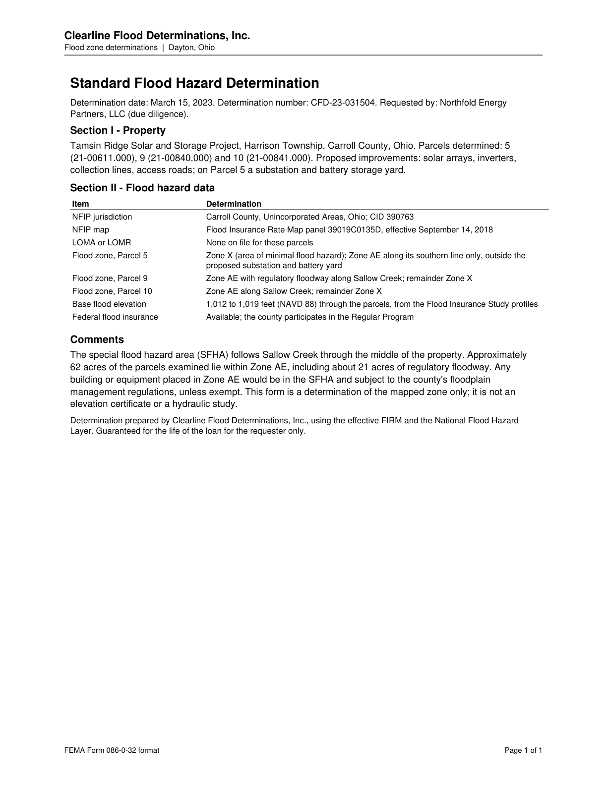
Page 1 of Standard Flood Hazard Determination - Tamsin Ridge Parcels 5, 9 and 10
  1. C-0c116fdc65

    Approximately 62 acres of the examined parcels lie within Zone AE, including about 21 acres of regulatory floodway.

    Quoted from page 1
    Approximately 62 acres of the parcels examined lie within Zone AE, including about 21 acres of regulatory floodway.

    Standard Flood Hazard Determination - Tamsin Ridge Parcels 5, 9 and 10 · DR-0009 · Page 1 · 2023-03-15

    Source agency_determination · Claim type extent · Polarity presence · Confidence high · Quote check exact, 100 of 100

  2. C-21574b55b6

    Carroll County participates in the NFIP; a mapped floodplain of Sallow Creek exists, and the county floodplain administrator should be contacted.

    Quoted from page 1
    Contact the county floodplain administrator about development in the mapped floodplain of Sallow Creek.

    ODNR Environmental Review - Tamsin Ridge Solar and Storage Project (ODNR 23-0477) · DR-0011 · Page 1 · 2023-05-02

    Source agency_determination · Claim type presence · Polarity presence · Confidence medium · Quote check exact, 100 of 100

  3. C-2227c77011

    County floodplain regulations exempt major utility facilities permitted by the Power Siting Board.

    Quoted from page 1
    They exempt major utility facilities permitted by the Power Siting Board.

    Zoning Verification - Tamsin Ridge Solar and Storage Project · DR-0022 · Page 1 · 2023-02-14

    Source agency_determination · Claim type regulatory · Polarity absence · Confidence medium · Quote check exact, 100 of 100

  4. C-29b335e462

    The SFHA follows Sallow Creek through the middle of the property.

    Quoted from page 1
    The special flood hazard area (SFHA) follows Sallow Creek through the middle of the property.

    Standard Flood Hazard Determination - Tamsin Ridge Parcels 5, 9 and 10 · DR-0009 · Page 1 · 2023-03-15

    Source agency_determination · Claim type presence · Polarity presence · Confidence medium · Quote check exact, 100 of 100

    Cited by AQ-01 · Filed under AQ-01

  5. C-3181379aaa

    FEMA maps Zone AE with a regulatory floodway along Sallow Creek through the middle of the site.

    Quoted from page 2
    AE, with a regulatory floodway, along Sallow Creek through the middle of the site.

    Stormwater, Floodplain and Drainage Memo - Tamsin Ridge Solar and Storage Project · DR-0019 · Page 2 · 2023-06-05

    Source map_or_figure · Claim type presence · Polarity presence · Confidence high · Quote check exact, 100 of 100

  6. C-417a553cb9

    Parcel 5 is mostly Zone X, with Zone AE along its southern line only, outside the proposed substation and battery yard.

    Quoted from page 1
    Zone X (area of minimal flood hazard); Zone AE along its southern line only, outside the proposed substation and battery yard

    Standard Flood Hazard Determination - Tamsin Ridge Parcels 5, 9 and 10 · DR-0009 · Page 1 · 2023-03-15

    Source agency_determination · Claim type presence · Polarity presence · Confidence high · Quote check exact, 100 of 100

  7. C-546dd83365

    About 14 acres of array rows are in the flood fringe on Parcels 9 and 10.

    Quoted from page 2
    About 14 acres of array rows are in the flood fringe (Zone AE outside the floodway) on Parcels 9 and 10,

    Stormwater, Floodplain and Drainage Memo - Tamsin Ridge Solar and Storage Project · DR-0019 · Page 2 · 2023-06-05

    Source consultant_memo · Claim type extent · Polarity presence · Confidence medium · Quote check exact, 100 of 100

    Cited by EG-01 · Filed under AQ-02, EG-01

  8. C-5edaac1379

    Buildings or equipment placed in Zone AE would be in the SFHA and subject to county floodplain management regulations, unless exempt.

    Quoted from page 1
    Any building or equipment placed in Zone AE would be in the SFHA and subject to the county's floodplain management regulations, unless exempt.

    Standard Flood Hazard Determination - Tamsin Ridge Parcels 5, 9 and 10 · DR-0009 · Page 1 · 2023-03-15

    Source agency_determination · Claim type regulatory · Polarity presence · Confidence high · Quote check exact, 100 of 100

    Filed under AQ-02, PE-01

  9. C-75d2a2cad3

    Flood fringe array rows should be checked against a local hydraulic model; if flood levels are higher than mapped, those 14 acres may need to be dropped.

    Quoted from page 2
    if flood levels prove higher than mapped, those 14 acres may need to be dropped.

    Stormwater, Floodplain and Drainage Memo - Tamsin Ridge Solar and Storage Project · DR-0019 · Page 2 · 2023-06-05

    Source consultant_memo · Claim type recommendation · Polarity neutral · Confidence medium · Quote check exact, 100 of 100

    Cited by EN-08 · Filed under AQ-02, EN-08

  10. C-81e2af2ba0

    Parcel 10 lies in Zone AE along Sallow Creek; the remainder is Zone X.

    Quoted from page 1
    Zone AE along Sallow Creek; remainder Zone X

    Standard Flood Hazard Determination - Tamsin Ridge Parcels 5, 9 and 10 · DR-0009 · Page 1 · 2023-03-15

    Source agency_determination · Claim type presence · Polarity presence · Confidence high · Quote check exact, 100 of 100

  11. C-846dff3266

    Carroll County floodplain regulations exempt major utility facilities permitted by OPSB, but OPSB staff expect the application to show compliance.

    Quoted from page 2
    Carroll County's floodplain regulations exempt major utility facilities permitted by the OPSB, but OPSB staff expect the application to show compliance with them.

    Stormwater, Floodplain and Drainage Memo - Tamsin Ridge Solar and Storage Project · DR-0019 · Page 2 · 2023-06-05

    Source consultant_memo · Claim type regulatory · Polarity neutral · Confidence medium · Quote check exact, 100 of 100

    Filed under AQ-02, PE-01, PE-02

  12. C-93c27ec8ff

    No arrays, inverters, substation, BESS yard or fill are placed in the floodway.

    Quoted from page 2
    No arrays, inverters, the substation, the BESS yard or fill are placed in the floodway.

    Stormwater, Floodplain and Drainage Memo - Tamsin Ridge Solar and Storage Project · DR-0019 · Page 2 · 2023-06-05

    Source consultant_memo · Claim type absence · Polarity absence · Confidence high · Quote check exact, 100 of 100

  13. C-9f6b8123d8

    Landowners report floodplain fields flood for a day or two most springs.

    Quoted from page 2
    the floodplain fields flood for a day or two most springs.

    Stormwater, Floodplain and Drainage Memo - Tamsin Ridge Solar and Storage Project · DR-0019 · Page 2 · 2023-06-05

    Source consultant_memo · Claim type presence · Polarity presence · Confidence medium · Quote check exact, 100 of 100

    Cited by EN-08 · Filed under AQ-02, EN-08

  14. C-beb33132a9

    No LOMA or LOMR is on file for these parcels.

    Quoted from page 1
    None on file for these parcels

    Standard Flood Hazard Determination - Tamsin Ridge Parcels 5, 9 and 10 · DR-0009 · Page 1 · 2023-03-15

    Source agency_determination · Claim type absence · Polarity absence · Confidence high · Quote check exact, 100 of 100

  15. C-d0039fd7b9

    Parcel 9 is in Zone AE with a regulatory floodway along Sallow Creek; the remainder is Zone X.

    Quoted from page 1
    Zone AE with regulatory floodway along Sallow Creek; remainder Zone X

    Standard Flood Hazard Determination - Tamsin Ridge Parcels 5, 9 and 10 · DR-0009 · Page 1 · 2023-03-15

    Source agency_determination · Claim type presence · Polarity presence · Confidence high · Quote check exact, 100 of 100

  16. C-db721b9fe7

    Landowners report Sallow Creek overtopped Linnet Road at the county bridge in the June 2019 flash flood.

    Quoted from page 2
    Landowners report that Sallow Creek overtopped Linnet Road at the county bridge during the

    Stormwater, Floodplain and Drainage Memo - Tamsin Ridge Solar and Storage Project · DR-0019 · Page 2 · 2023-06-05

    Source consultant_memo · Claim type presence · Polarity presence · Confidence medium · Quote check exact, 100 of 100

    Cited by EN-08 · Filed under AQ-02, EN-08

Requirements and permits

The requirements the assessor tied to this row, by level. Each quote from dated law is shown with its source.

Federal

  • Floodplain development permit

    F-NFIP · Local floodplain administrator (NFIP community), FEMA

    Applicability
    Conditional
    Instrument
    National Flood Insurance Program (44 CFR Parts 59-60) and local flood damage prevention ordinance
    Trigger
    Equipment, fill or structures in a mapped flood hazard area.
    Description

    Development within a FEMA Special Flood Hazard Area requires a local floodplain development permit; floodway encroachment needs a no-rise analysis.

    Typical timeline

    Typical: 2 to 6 weeks for a local floodplain development permit, and 3 to 6 months or more where a floodway no-rise analysis or map revision is needed (basis: practice, not stated in the sources).

    Verification
    PACK_PENDING_QUALIFIED_REVIEW
    Source
    pack:federal
    In the permit matrix
    F-NFIP
    Legal basis: 3 quotes from dated law
    Quoted from the law, page 1
    Require permits for all proposed construction and other developments including the placement of manufactured homes, within Zone A on the community's FHBM or FIRM

    Source 44CFR60 · page 1 · version 2023-08-01

    Cited for requirement: local development permit

    In force from 2017-01-03 to 2026-10-07

    eCFR versioner: 44 CFR part 60, same text on 2021-10-15, 2022-05-20, 2022-09-12, 2023-04-22, 2023-08-01 and on every amendment date between them; amendment dates 2017-01-03

    May be cited on the cut-off date.

    Quoted from the law, page 1
    Development means any man-made change to improved or unimproved real estate, including but not limited to buildings or other structures, mining, dredging, filling, grading, paving, excavation or drilling operations or storage of equipment or materials.

    Source 44CFR59 · page 1 · version 2023-08-01

    Cited for trigger: development (fill, grading, storage of equipment)

    In force from 2021-10-01 to 2026-10-07

    eCFR versioner: 44 CFR part 59, same text on 2021-10-15, 2022-05-20, 2022-09-12, 2023-04-22, 2023-08-01 and on every amendment date between them; amendment dates 2017-01-03, 2018-07-05, 2018-10-01, 2020-07-20, 2020-10-30, 2020-12-02, 2021-08-03, 2021-10-01

    May be cited on the cut-off date.

    Quoted from the law, page 1
    Prohibit encroachments, including fill, new construction, substantial improvements, and other development within the adopted regulatory floodway unless it has been demonstrated through hydrologic and hydraulic analyses performed in accordance with standard engineering practice that the proposed encroachment would not result in any increase in flood levels within the community during the occurrence of the base flood discharge

    Source 44CFR60 · page 1 · version 2023-08-01

    Cited for trigger: floodway no-rise analysis

    In force from 2017-01-03 to 2026-10-07

    eCFR versioner: 44 CFR part 60, same text on 2021-10-15, 2022-05-20, 2022-09-12, 2023-04-22, 2023-08-01 and on every amendment date between them; amendment dates 2017-01-03

    May be cited on the cut-off date.

Local

  • Floodplain development permit for development in a Special Flood Hazard Area

    CCO-FLOOD · Carroll County Floodplain Administrator

    Applicability
    Conditional
    Instrument
    Carroll County Special Purpose Flood Damage Reduction regulations (county flood plain regulations), revised 2010-04-08 (section 1.1 cites ORC 307.37 and 307.85); FEMA Community Status Book for Ohio of 2023-05-11 (Carroll County, CID 390763B)
    Trigger
    Filling, grading, construction or other development wholly or partly in, or in contact with, a Special Flood Hazard Area on the county's adopted flood maps, unless it is a major utility facility permitted by the Ohio Power Siting Board.
    Description

    Development wholly or partly in, or in contact with, a Special Flood Hazard Area on the county's adopted flood maps needs a floodplain development permit from the Floodplain Administrator before work starts. The county's definition may also reach flood-prone areas designated from other sources, such as historical flood information and flood-prone soils associated with a watercourse, so a FEMA-map screen may understate it. FEMA's Community Status Book of 2023-05-11 lists Carroll County (CID 390763B) in the National Flood Program; by column position in the PDF its current effective map date is 2018-09-14. The regulations list 'Major utility facilities permitted by the Ohio Power Siting Board under Section 4906' among the exemptions from filing, and an exempt action is exempt from the standards too. ORC 4906.13(B) likewise bars a political subdivision from requiring 'any approval, consent, permit, certificate, or other condition' for an OPSB-certificated facility, so the permit matters mainly for work outside the certificate.

    Typical timeline

    The Floodplain Administrator approves or disapproves within 30 days after a complete application, and every permit is conditional upon the commencement of work within one year (regulations section 3.5(B)).

    As of the cut-off

    As of the cut-off: Initial effective date of the Carroll County Flood Insurance Rate Map, as stated in the county regulations' definition of 'New Construction'; it matches the initial-FIRM column of FEMA's row. (1990-09-28) County flood damage reduction regulations revised (revision date on their cover); no later revision is in the library. (2010-04-08) Current effective map date for Carroll County in FEMA's Community Status Book of 2023-05-11 (identified by column position in the PDF; the extracted text lists 09/14/18, 09/28/90, 09/28/90 and 11/04/77 without labels). (2018-09-14) ORC 4906.13 (No local jurisdiction) took effect in the version in force on 2023-08-01 (House Bill 6, 133rd General Assembly). (2019-10-22) Date of the FEMA Community Status Book for Ohio used here. (2023-05-11)

    Verification
    PACK_PENDING_QUALIFIED_REVIEW
    Source
    pack:oh_carroll_county.json
    In the permit matrix
    CCO-FLOOD
    Legal basis: 8 quotes from dated law
    Quoted from the law, page 11
    to begin construction or other development activity including but not limited to filling; grading; construction; alteration, remodeling, or expanding any structure; or alteration of any watercourse wholly within, partially within or in contact with any identified special flood hazard area, as established in Section 1.6, until a floodplain development permit is obtained from the Floodplain Administrator.

    Source Carroll County OH Flood Plain Regulations revised 2010 04 08 · page 11 · version 2022-05-19

    May be cited on the cut-off date.

    Quoted from the law, page 2
    For the purposes of these regulations, the following studies and / or maps are adopted: A. Flood Insurance Study Carroll County, Ohio and Incorporated Areas and Flood Insurance Rate Map Carroll county, Ohio and Incorporated Areas.

    Source Carroll County OH Flood Plain Regulations revised 2010 04 08 · page 2 · version 2022-05-19

    May be cited on the cut-off date.

    Quoted from the law, page 9
    Special flood hazard areas may also refer to areas that are flood prone and designated from other federal state or local sources of data including but not limited to historical flood information reflecting high water marks, previous flood inundation areas, and flood prone soils associated with a watercourse.

    Source Carroll County OH Flood Plain Regulations revised 2010 04 08 · page 9 · version 2022-05-19

    May be cited on the cut-off date.

    Quoted from the law, page 13
    Within thirty (30) days after the receipt of a complete application, the Floodplain Administrator shall either approve or disapprove the application. If an application is approved, a floodplain development permit shall be issued. All floodplain development permits shall be conditional upon the commencement of work within one (1) year.

    Source Carroll County OH Flood Plain Regulations revised 2010 04 08 · page 13 · version 2022-05-19

    May be cited on the cut-off date.

    Quoted from the law, page 14
    C. Major utility facilities permitted by the Ohio Power Siting Board under Section 4906 of the Ohio Revised Code.

    Source Carroll County OH Flood Plain Regulations revised 2010 04 08 · page 14 · version 2022-05-19

    May be cited on the cut-off date.

    Quoted from the law, page 14
    Any proposed action exempt from filing for a floodplain development permit is also exempt from the standards of these regulations.

    Source Carroll County OH Flood Plain Regulations revised 2010 04 08 · page 14 · version 2022-05-19

    May be cited on the cut-off date.

    Quoted from the law, page 3
    390763B CARROLL COUNTY * CARROLL COUNTY 09/14/18 09/28/90 09/28/90 11/04/77 No 390048# CARROLLTON, VILLAGE OF CARROLL COUNTY 06/04/10(M) 08/19/85 08/19/85 01/16/74 No

    Source FEMA Community Status Book Ohio · page 3 · version 2023-05-11

    May be cited on the cut-off date.

    Quoted from the law, page 20
    No public agency or political subdivision of this state may require any approval, consent, permit, certificate, or other condition for the construction or operation of a major utility facility or economically significant wind farm authorized by a certificate issued pursuant to Chapter 4906. of the Revised Code.

    Source ORC 4906 Power Siting Board · page 20 · version 2023-08-01

    In force from 2019-10-22 to 2026-10-03, section 4906.13

    4906.13: version effective 2019-10-22, still the current version when the page map was checked (2026-10-03)

    May be cited on the cut-off date.

Information requests

No information request for this row.

Next steps

  • Run a local hydraulic model for the 14 acres of fringe arrays; drop rows if flood levels exceed mapped levels.
  • Keep all equipment out of the floodway.
  • Show compliance with county floodplain rules in the OPSB application; ask the county floodplain administrator to confirm adopted flood-prone areas and permit position.

Agencies

  • FEMA
  • Carroll County
  • OPSB

Cost and impact

Impact
C, S
Potential cost level
L-M
Why

About 14 acres of fringe arrays may need a hydraulic model or removal from the layout. The floodway is avoided.

Impact: C = cost, S = schedule. Potential cost level: L, L-M, M, M-H, H (relative to a utility-scale solar budget).

Lumerian Labs 2026