Code computed the rating from the assessor's inputs:
impact_likely=yes -> 2
Set by the rule
Decision
Released with flags
The engine's reasons
Agencies not in the register or the evidence: Carroll County Engineer, FEMA
Independent assessments split on the category (5 samples: {'2': 4, '1': 1})
Evidence state
Reported · desktop, consultant or developer record
Worst case
The same rule on the worst case gives no rating above the point.
Scenario
Flood levels prove higher than mapped, the 14 flood-fringe acres are dropped, and access via Linnet Road and elevated equipment need non-standard design and higher deductibles.
Step still pending
Local hydraulic model of Sallow Creek and insurer hail and flood review
Local flood history beyond FEMA mapping is documented: landowners report floodplain fields flood for a day or two most springs (C-9f6b8123d8) and Sallow Creek overtopped Linnet Road in the June 2019 flash flood (C-db721b9fe7). Seasonal high groundwater may be near the surface in the floodplain (C-05146fd25c). Hail, wildfire and heat are not addressed. The seismic-low finding (C-560f40e113) belongs to EN-02 and does not offset this.
Flooding and shallow groundwater are tied to the Sallow Creek floodplain, part of the site; about 14 flood-fringe acres are flagged as possibly dropped (C-75d2a2cad3). Design loads of 115 mph wind and 20 psf snow are standard (C-4f11de30a3).
Siting outside the floodplain, dropping the 14 flood-fringe acres if a local hydraulic model shows higher levels (C-75d2a2cad3), and elevated equipment and drainage design answer the documented flood exposure.
No hazard approval is documented. Building code loads and drainage review near the floodplain apply at routine terms; construction stormwater coverage is separate (C-4bf6e9a178). Basins are below dam permit size (C-ebc49abde3).
Recurring spring flooding, a flash flood that overtopped the county bridge on Linnet Road, and near-surface seasonal groundwater make a physical or design effect likely if array rows or access routes lie in or near the floodplain (C-9f6b8123d8, C-db721b9fe7, C-05146fd25c, C-75d2a2cad3).
Landowners report floodplain fields flood for a day or two most springs, and Sallow Creek overtopped Linnet Road at the county bridge in the June 2019 flash flood. Seasonal high groundwater may be near the surface in the floodplain. Design wind is 115 mph and snow load 20 psf. No hail or wildfire screen is in the data room.
Critique
Verdict
upheld
Suggested direction for the rating
same
Summary
Category 2 is plausible given reported recurring flooding and shallow groundwater. Weaknesses: extent 'peripheral' and the 14 acres' location lack quoted support, the June 2019 date isn't in the quote, and the agencies list (County Engineer, FEMA) is unsupported.
Critic model
Luminol
Issues
Severity minor · Kind unsupported_statement
Rationale and worst case say flooding is tied to the Sallow Creek floodplain and 14 flood-fringe acres 'part of the site', but quotes do not name Sallow Creek as the floodplain source of the spring flooding, nor give the 14 acres' location or the extent of the floodplain. 'Peripheral' rests on no quoted extent. Overtopping of Linnet Road at a county bridge is off-site access, not on-site extent. Settling evidence: floodplain acreage/overlay vs. layout.
Cited claim C-db721b9fe7 is truncated and does not show the Linnet Road overtopping was 'June 2019 flash flood' or a 'county bridge' flash flood. The year/event type are unsupported by the quote. Also the quote shows landowner reports, not documented measurement; 'flash flood' is overstated.
Pathway rationale cites C-4bf6e9a178 and C-ebc49abde3 (stormwater permit, dam size) but quotes are truncated. 'Drainage review by Carroll County Engineer' and 'FEMA' as agencies are not supported by any claim or requirement; the Carroll County Engineer role is not documented. Ohio EPA is for construction stormwater, which is outside this row's hazard scope.
Worst case says 'avoidable partly' while point input is avoidable yes, and 'higher deductibles' and 'non-standard design' are not supported by any claim; the insurer review is not a documented pending step in the data room. It does name a real pending step (hydraulic model), so only mild overstatement.
Next steps should include obtaining the flood-level/hydraulic study basis and overlaying the floodplain on the layout; also the 0.5-inch ice applies only to gen-tie structures, but the assessment frames design loads generally. Minor wording.
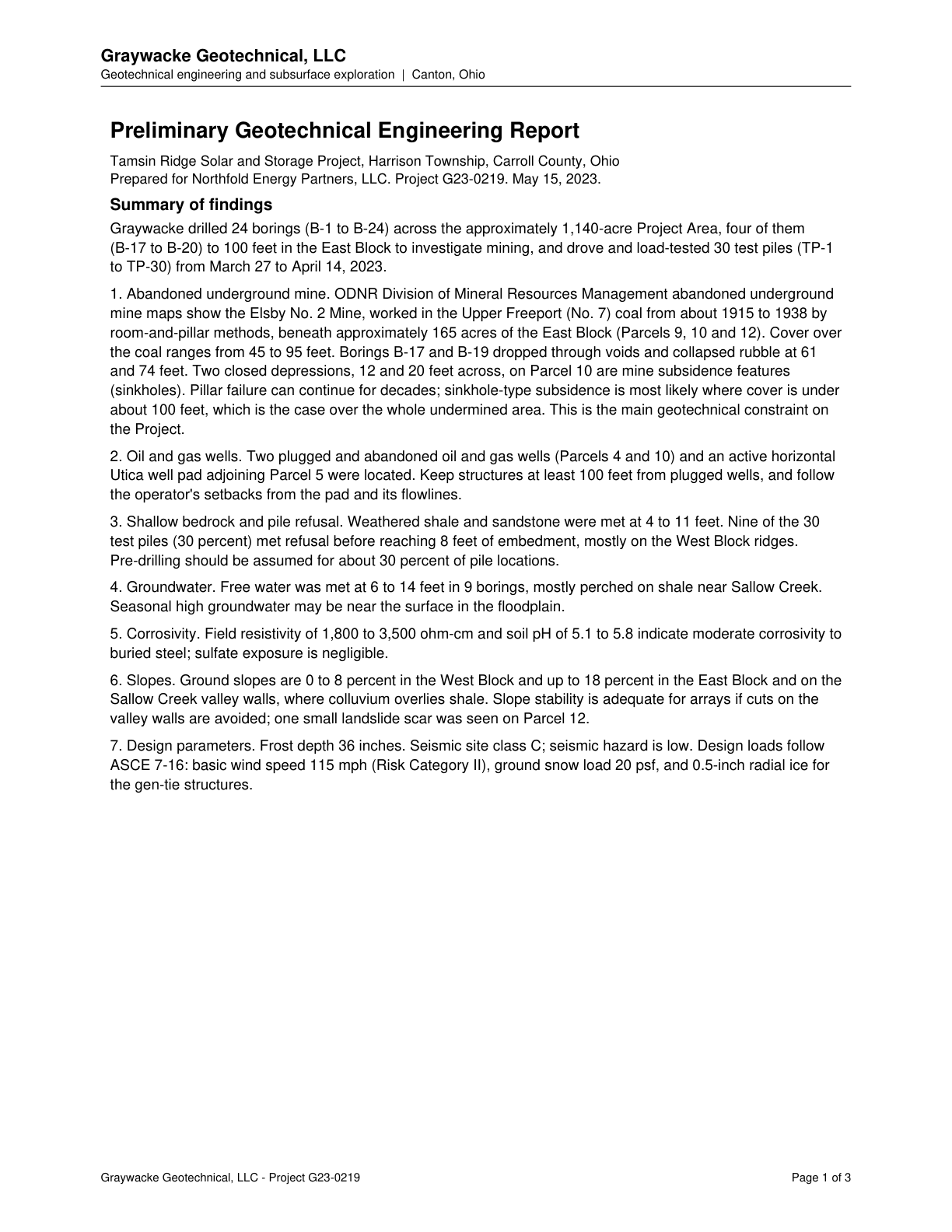
Free water was met at 6 to 14 feet in 9 borings, mostly perched near Sallow Creek; seasonal high groundwater may be near the surface in the floodplain.
Quote check Exact · Placed verbatim · The quote occurs on the page exactly as written. · Read as native
Graywacke Geotechnical, LLC
Geotechnical engineering and subsurface exploration | Canton, Ohio
Preliminary Geotechnical Engineering Report
Tamsin Ridge Solar and Storage Project, Harrison Township, Carroll County, Ohio
Prepared for Northfold Energy Partners, LLC. Project G23-0219. May 15, 2023.
Summary of findings
Graywacke drilled 24 borings (B-1 to B-24) across the approximately 1,140-acre Project Area, four of them
(B-17 to B-20) to 100 feet in the East Block to investigate mining, and drove and load-tested 30 test piles (TP-1
to TP-30) from March 27 to April 14, 2023.
1. Abandoned underground mine. ODNR Division of Mineral Resources Management abandoned underground
mine maps show the Elsby No. 2 Mine, worked in the Upper Freeport (No. 7) coal from about 1915 to 1938 by
room-and-pillar methods, beneath approximately 165 acres of the East Block (Parcels 9, 10 and 12). Cover over
the coal ranges from 45 to 95 feet. Borings B-17 and B-19 dropped through voids and collapsed rubble at 61
and 74 feet. Two closed depressions, 12 and 20 feet across, on Parcel 10 are mine subsidence features
(sinkholes). Pillar failure can continue for decades; sinkhole-type subsidence is most likely where cover is under
about 100 feet, which is the case over the whole undermined area. This is the main geotechnical constraint on
the Project.
2. Oil and gas wells. Two plugged and abandoned oil and gas wells (Parcels 4 and 10) and an active horizontal
Utica well pad adjoining Parcel 5 were located. Keep structures at least 100 feet from plugged wells, and follow
the operator's setbacks from the pad and its flowlines.
3. Shallow bedrock and pile refusal. Weathered shale and sandstone were met at 4 to 11 feet. Nine of the 30
test piles (30 percent) met refusal before reaching 8 feet of embedment, mostly on the West Block ridges.
Pre-drilling should be assumed for about 30 percent of pile locations.
4. Groundwater. Free water was met at 6 to 14 feet in 9 borings, mostly perched on shale near Sallow Creek.
Quote starts. Seasonal high groundwater may be near the surface in the floodplain. Quote ends.
5. Corrosivity. Field resistivity of 1,800 to 3,500 ohm-cm and soil pH of 5.1 to 5.8 indicate moderate corrosivity to
buried steel; sulfate exposure is negligible.
6. Slopes. Ground slopes are 0 to 8 percent in the West Block and up to 18 percent in the East Block and on the
Sallow Creek valley walls, where colluvium overlies shale. Slope stability is adequate for arrays if cuts on the
valley walls are avoided; one small landslide scar was seen on Parcel 12.
7. Design parameters. Frost depth 36 inches. Seismic site class C; seismic hazard is low. Design loads follow
ASCE 7-16: basic wind speed 115 mph (Risk Category II), ground snow load 20 psf, and 0.5-inch radial ice for
the gen-tie structures.
Graywacke Geotechnical, LLC - Project G23-0219 Page 1 of 3
The outline marks where the quote begins on the page.
C-05146fd25c
Free water was met at 6 to 14 feet in 9 borings, mostly perched near Sallow Creek; seasonal high groundwater may be near the surface in the floodplain.
Quoted from page 1
Seasonal high groundwater may be near the surface in the floodplain.
Flood fringe array rows should be checked against a local hydraulic model; if flood levels are higher than mapped, those 14 acres may need to be dropped.
Quoted from page 2
if flood levels
prove higher than mapped, those 14 acres may need to be dropped.
The requirements the assessor tied to this row, by level. Each quote from dated law is shown with its source.
No requirement is tied to this row.
Information requests
IR-96d020deb4 · Medium priority
Provide the hazard or climate risk screen (national hazard index, wildfire risk map, hail or tornado frequency data, lender or insurer screen) for the project area, or confirm none exists.
Missing evidence
Hazard or climate risk screen (national hazard index, wildfire risk map, hail or tornado frequency data, lender or insurer screen)
Consequence
Natural Hazards and Climate Exposure is rated on partial evidence without it.
Blocks the decision
No
Raised by
completeness
IR-0011d0e4ed · Medium priority
Provide the design basis report or engineering study (design wind speed, snow and ice loads, module hail rating, stow strategy, design temperature) for the project area, or confirm none exists.
Missing evidence
Design basis report or engineering study (design wind speed, snow and ice loads, module hail rating, stow strategy, design temperature)
Consequence
Natural Hazards and Climate Exposure is rated on partial evidence without it.
Blocks the decision
No
Raised by
completeness
IR-248c346d8e · Medium priority
Provide the wildfire hazard zone designation, wildfire protection plan, or local flood, drainage and dam inundation history beyond fema mapping for the project area, or confirm none exists.
Missing evidence
Wildfire hazard zone designation, wildfire protection plan, or local flood, drainage and dam inundation history beyond FEMA mapping
Consequence
Natural Hazards and Climate Exposure is rated on partial evidence without it.
Blocks the decision
No
Raised by
completeness
Next steps
Keep arrays and equipment out of the flood fringe or run the local hydraulic model; confirm Linnet Road access during floods.
Request design basis report, insurer hail and wind loss history, and any climate or wildfire screen.
Agencies
Carroll County Engineer
Ohio EPA
FEMA
Cost and impact
Impact
C, S
Potential cost level
L-M
Why
Flood-fringe layout adjustment, drainage design and possible loss of about 14 acres; standard design and insurance otherwise. Hail and wildfire insurance terms are unknown.
Impact: C = cost, S = schedule. Potential cost level: L, L-M, M, M-H, H (relative to a utility-scale solar budget).
Comments
Landowners report floodplain fields flood for a day or two most springs, and Sallow Creek overtopped Linnet Road at the county bridge in the June 2019 flash flood. Seasonal high groundwater may be near the surface in the floodplain. Design wind is 115 mph and snow load 20 psf. No hail or wildfire screen is in the data room.