Code computed the rating from the assessor's inputs:
extent=core, avoidable=partly -> 3
Set by the rule
Decision
Released
Evidence state
Reported · desktop, consultant or developer record
Worst case
The same rule on the worst case gives no rating above the point.
Scenario
Extensive untiled-map tile damage, full CAUV recoupment and district withdrawal penalties, and a ditch improvement petition for a crossing; still manageable through standard processes.
Step still pending
Drain tile locating survey, county auditor confirmation of the energy facility exception, and county engineer review of ditch crossings
SSURGO maps about 62 percent prime farmland plus 21 percent statewide importance (C-dd848d6716). Twelve parcels are in CAUV and eight in an agricultural district (C-1a003c9f9c). Landowners report tile across most West Block parcels (C-c8e5735fc6), and the ditch crosses Parcel 3 (C-d07aa54486). Program enrollment affects much of the site.
Costs are tile repair or rerouting (C-50cd3eb7bc, C-f3753971f3, C-b49803fd5c) and CAUV recoupment and withdrawal penalty, unless the energy facility exception applies (C-1a003c9f9c, C-78fa553551). No binding agricultural easement is documented, so not 'no'.
Recoupment is a charge, not a permit (OH-AG). OPSB requires mapping of agricultural district land and a tile repair plan (C-752c6c08a4). A county ditch petition is needed only if the ditch is altered (OH-DITCH, C-83e349f335). No discretionary easement approval or prohibition is documented. No federal nexus is shown for the FPPA.
Tile damage during grading, trenching and collection lines is likely on tiled West Block fields (C-682e211cfb, C-c8e5735fc6). Farmland conversion and possible recoupment are also likely (C-78fa553551, C-67ba142a5a).
SSURGO maps about 62 percent of the land as prime farmland. Twelve parcels are enrolled in CAUV and eight are in an agricultural district; recoupment may apply unless the energy facility exception applies. Field tile is reported in West Block fields. Harrison Township No. 4 county ditch crosses Parcel 3, with a 25-foot maintenance easement.
Critique
Verdict
upheld
Suggested direction for the rating
same
Summary
Core assessment is broadly supported: category 3 is reasonable. Minor wording and support gaps remain: 'most West Block', the 25-foot easement, and a vague worst-case phrase. The county engineer crossing confirmation is also missing from the next steps. No major defect found.
Critic model
Luminol
Issues
Severity minor · Kind unsupported_statement
Rationale says 'Landowners report tile across most West Block parcels'. The quote (C-c8e5735fc6) lists Parcels 1 to 4, 6 and 8 'and on...' (truncated). 'Most' of West Block is not shown, and the West Block parcel count is not given. Tile in 2 test pits (C-682e211cfb) is thin. A tile survey would settle this.
Extent 'core' rests on 'program enrollment affects much of the site'. Twelve of 14 parcels in CAUV is supported only by the parcel count, not by acreage. The 21 percent statewide-importance figure is cut off in the quote ('another 21 percent') and is not tied to 'statewide importance'. The prime farmland figure is also a desktop SSURGO map, so core is a judgment call.
The comments state the ditch has a '25-foot maintenance easement'. The quote says 'within 25 feet of the top of each bank', which is a statutory maximum measured from the bank, not a surveyed easement on Parcel 3. The ditch is also described as 'open' only by inference.
The worst-case scenario refers to 'Extensive untiled-map tile damage'. This is an odd phrase and no cited claim shows unmapped tile. It also repeats the point inputs and adds no pending finding that could make extent or avoidability worse. The only real pending steps are the auditor confirmation and the survey.
Next steps omit confirming with the county engineer what a ditch crossing needs. The OH-DITCH description says the chapters set out no separate crossing permit. The worst case names this as pending, but the next steps do not include it. They also omit confirming FPPA non-applicability, such as whether any federal funding is involved.
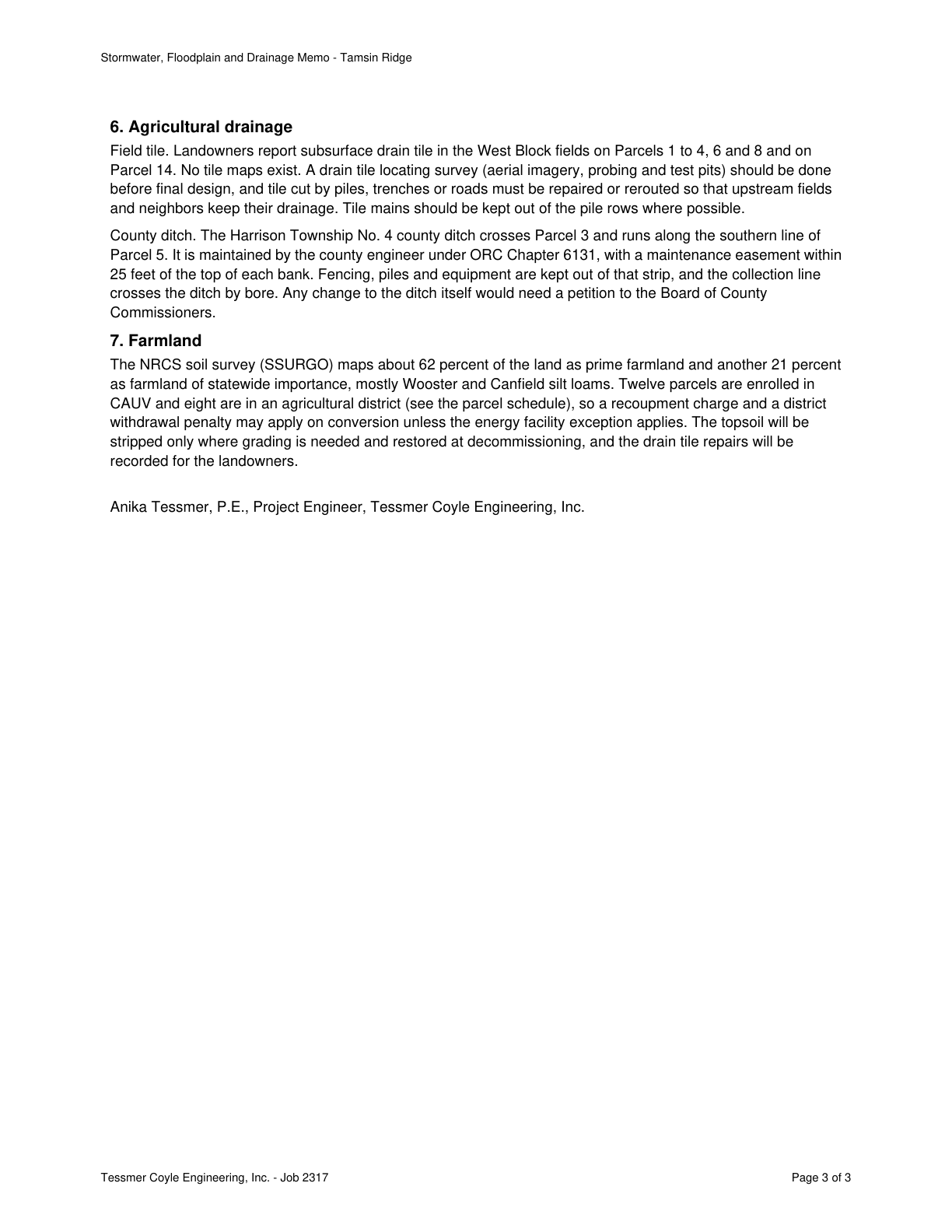
Twelve parcels are enrolled in CAUV and eight are in an agricultural district; recoupment charge and withdrawal penalty may apply unless the energy facility exception applies.
Quote check Exact · Placed normalised · The quote matches the page once line breaks, hyphenation, case and punctuation are set aside, as the engine's matcher compares text. The marked words are the page's own. · Read as native
Stormwater, Floodplain and Drainage Memo - Tamsin Ridge
6. Agricultural drainage
Field tile. Landowners report subsurface drain tile in the West Block fields on Parcels 1 to 4, 6 and 8 and on
Parcel 14. No tile maps exist. A drain tile locating survey (aerial imagery, probing and test pits) should be done
before final design, and tile cut by piles, trenches or roads must be repaired or rerouted so that upstream fields
and neighbors keep their drainage. Tile mains should be kept out of the pile rows where possible.
County ditch. The Harrison Township No. 4 county ditch crosses Parcel 3 and runs along the southern line of
Parcel 5. It is maintained by the county engineer under ORC Chapter 6131, with a maintenance easement within
25 feet of the top of each bank. Fencing, piles and equipment are kept out of that strip, and the collection line
crosses the ditch by bore. Any change to the ditch itself would need a petition to the Board of County
Commissioners.
7. Farmland
The NRCS soil survey (SSURGO) maps about 62 percent of the land as prime farmland and another 21 percent
as farmland of statewide importance, mostly Wooster and Canfield silt loams. Quote starts. Twelve parcels are enrolled in
CAUV and eight are in an agricultural district Quote ends. (see the parcel schedule), so a recoupment charge and a district
withdrawal penalty may apply on conversion unless the energy facility exception applies. The topsoil will be
stripped only where grading is needed and restored at decommissioning, and the drain tile repairs will be
recorded for the landowners.
Anika Tessmer, P.E., Project Engineer, Tessmer Coyle Engineering, Inc.
Tessmer Coyle Engineering, Inc. - Job 2317 Page 3 of 3
The outline marks where the quote begins on the page.
C-1a003c9f9c
Twelve parcels are enrolled in CAUV and eight are in an agricultural district; recoupment charge and withdrawal penalty may apply unless the energy facility exception applies.
Quoted from page 3
Twelve parcels are enrolled in
CAUV and eight are in an agricultural district
Harrison Township No. 4 county ditch crosses Parcel 3 and runs along the southern line of Parcel 5, with a maintenance easement within 25 feet of each bank top.
Quoted from page 3
The Harrison Township No. 4 county ditch crosses Parcel 3 and runs along the southern line of
Parcel 5.
The requirements the assessor tied to this row, by level. Each quote from dated law is shown with its source.
State
Recoupment of CAUV tax savings and agricultural district withdrawal penalty when land leaves agricultural use, and the OPSB's review of agricultural district land (a cost and a review, not a permit)
OH-AG · County auditor (agricultural district and CAUV administration, recoupment charge, withdrawal penalty); Ohio Power Siting Board (OPSB) (agricultural district impact in the certificate decision)
Applicability
Conditional
Instrument
ORC 929.01 to 929.05 (agricultural districts); ORC 5713.30 to 5713.38 (current agricultural use valuation, CAUV); ORC 4906.10(A)(7); OAC 4906-4-08(E)
Trigger
Land enrolled in CAUV or an agricultural district is converted to a non-agricultural use by the project.
Description
Two county programs govern farmland: current agricultural use value (CAUV), a property-tax relief program, and agricultural districts under ORC Chapter 929. Neither is a permit; the cost arises when land leaves agricultural use. On conversion, a charge is levied equal to the tax savings on the converted land over the three preceding tax years. Withdrawal from an agricultural district, which includes conversion to a non-agricultural use, adds a penalty of a percentage of that charge equal to the average bank prime rate. No charge is levied where the conversion is incident to constructing an energy facility, as defined in ORC 5727.01, and the rest of the parcel stays in agricultural use; that definition was not in the source library, so confirm that a solar and storage facility qualifies. The OPSB weighs impact on agricultural district land in its certificate findings and requires agricultural and district land to be mapped.
Typical timeline
The CAUV recoupment reaches back three tax years before the year of conversion (ORC 5713.34(A)(1)); the district penalty uses the average bank prime rate at the time that charge is required to be paid (ORC 929.02(D)(1)(a)).
A companion law is the current agricultural use valuation (CAUV) program. The CAUV provides relief on farmland property taxes. Please contact your local county auditor's office for more information about the agricultural district or CAUV programs.
Source ODA agricultural district form page · page 1 · version 2023-01-28
May be cited on the cut-off date.
Quoted from the law, page 1
"Withdrawal from an agricultural district" includes the explicit removal of land from an agricultural district, conversion of land in an agricultural district to use for purposes other than agricultural production, and withdrawal of land from a land retirement or conservation program to use for purposes other than agricultural production.
In force from 2020-03-27 to 2026-10-03, section 929.01
929.01: version effective 2020-03-27, still the current version when the page map was checked (2026-10-03)
May be cited on the cut-off date.
Quoted from the law, page 5
the owner shall pay a percentage of the amount charged under section 5713.34 of the Revised Code that is equal to the average bank prime rate at the time the amount charged under that section is required to be paid. The withdrawal penalty shall be in addition to the amount charged under that section.
In force from 2018-11-02 to 2026-10-03, section 929.02
929.02: version effective 2018-11-02, still the current version when the page map was checked (2026-10-03)
May be cited on the cut-off date.
Quoted from the law, page 29
a portion of the tax savings upon such converted land shall be recouped as provided for by Section 36, Article II, Ohio Constitution by levying a charge on such land in an amount equal to the amount of the tax savings on the converted land during the three tax years immediately preceding the year in which the conversion occurs.
In force from 2017-09-29 to 2025-04-02, section 5713.34
5713.34: version effective 2017-09-29; first change after it 2025-04-03 (H.B. 315, 135th GA), from codes.ohio.gov version history in archive captures (confirmed_two_sources)
May be cited on the cut-off date.
Quoted from the law, page 29
A charge shall not be levied under this section for the conversion of a portion of a tract, lot, or parcel of land devoted exclusively to agricultural use if the conversion is incident to the construction or installation of an energy facility, as defined in section 5727.01 of the Revised Code
In force from 2017-09-29 to 2025-04-02, section 5713.34
5713.34: version effective 2017-09-29; first change after it 2025-04-03 (H.B. 315, 135th GA), from codes.ohio.gov version history in archive captures (confirmed_two_sources)
May be cited on the cut-off date.
Quoted from the law, page 21
shall not cause the remaining portion of the tract, lot, or parcel to be regarded as a conversion of land devoted exclusively to agricultural use if the remaining portion of the tract, lot, or parcel continues to be devoted exclusively to agricultural use.
In force from 2021-04-12 to 2025-04-02, section 5713.30
5713.30: version effective 2021-04-12; first change after it 2025-04-03 (H.B. 315, 135th GA), from codes.ohio.gov version history in archive captures (confirmed_two_sources)
May be cited on the cut-off date.
Quoted from the law, page 17
what its impact will be on the viability as agricultural land of any land in an existing agricultural district established under Chapter 929. of the Revised Code that is located within the site and alternative site of the proposed major utility facility.
Source ORC 4906 Power Siting Board · page 17 · version 2023-08-01
In force from 2021-10-11 to 2025-08-13, section 4906.10
4906.10: version effective 2021-10-11; first change after it 2025-08-14 (Am. Sub. H.B. 15, 136th GA), from codes.ohio.gov version history in archive captures (confirmed_two_sources)
May be cited on the cut-off date.
Quoted from the law, page 31
The applicant shall provide information regarding agricultural districts and potential impacts to agricultural land. (1) Mapping of agricultural land. The applicant shall identify on a map of at least 1:24,000 scale the proposed facility, all agricultural land, and separately all agricultural district land existing at least sixty days prior to submission of the application located within the project area boundaries.
In force from 2018-04-26 to 2024-05-29, section 4906-4-08
4906-4-08: version effective 2018-04-26; first change after it 2024-05-30 (OPSB Case 21-902-GE-BRO (determination 2023-07-20)), from codes.ohio.gov version history in archive captures (confirmed_two_sources)
May be cited on the cut-off date.
Petition proceeding before the board of county commissioners (or joint board) for any alteration of a county or joint county ditch, respect for the county's maintenance easement, and field tile protection and repair under the OPSB rules
OH-DITCH · Board of county commissioners (or the joint board of county commissioners for a joint county ditch) and the county engineer; Ohio Power Siting Board (OPSB) (field tile requirements in the certificate application)
The project would alter a county or joint county ditch, or build in the strip along it that maintenance crews may use.
Description
A petition for a county ditch goes to the board of county commissioners; where land in two or more counties is affected, a joint board of the counties' commissioners conducts the proceeding. For a single county ditch the county engineer has general charge of repair and maintenance. Filling, tiling, boxing, arching, relocating or otherwise changing a ditch is an improvement, which begins with a petition to the board. The permanent maintenance easement is not more than twenty-five feet from the top of the bank on an open ditch and not more than eighty feet centered on the centerline of a closed ditch. The chapters do not themselves set out a separate ditch-crossing permit, so confirm with the county engineer what a crossing needs. The OPSB application must show avoidance or minimization of damage to field tile and timely repair at the applicant's expense.
Typical timeline
After a petition is filed, the board sets a view between thirty and one hundred twenty days later and a first hearing thirty to ninety days after the view (ORC 6131.07(B)).
"Improvement" includes: (1) The location, construction, reconstruction, reconditioning, widening, deepening, straightening, altering, boxing, tiling, filling, walling, arching, or any change in the course, location, or terminus of any ditch, drain, watercourse, or floodway;
Source ORC 6131 6133 6137 county ditches · page 1 · version 2023-08-01
In force from 2021-03-24 to 2026-10-03, section 6131.01
6131.01: version effective 2021-03-24, still the current version when the page map was checked (2026-10-03)
May be cited on the cut-off date.
Quoted from the law, page 6
Any owner may file a petition for the construction of a drainage improvement with the clerk of the board of county commissioners of the county in which is located a part of the land proposed to benefit from the improvement.
Source ORC 6131 6133 6137 county ditches · page 6 · version 2023-08-01
In force from 2021-03-24 to 2026-10-03, section 6131.04
6131.04: version effective 2021-03-24, still the current version when the page map was checked (2026-10-03)
May be cited on the cut-off date.
Quoted from the law, page 10
which shall be between thirty and one hundred twenty days after the date on which the petition was filed with the clerk; (2) Establish a date and hour between thirty and ninety days after the date set for the view, when it will hold its first hearing on the petition.
Source ORC 6131 6133 6137 county ditches · page 10 · version 2023-08-01
In force from 2021-03-24 to 2026-10-03, section 6131.07
6131.07: version effective 2021-03-24, still the current version when the page map was checked (2026-10-03)
May be cited on the cut-off date.
Quoted from the law, page 79
When an improvement is proposed to be located in or benefits or damages land in two or more counties, the proceeding shall be conducted by a joint board of county commissioners consisting of the members of the boards of county commissioners of the several counties in which land may be benefited or damaged by the proposed improvement.
Source ORC 6131 6133 6137 county ditches · page 79 · version 2023-08-01
In force from 2021-03-24 to 2026-10-03, section 6133.02
6133.02: version effective 2021-03-24, still the current version when the page map was checked (2026-10-03)
May be cited on the cut-off date.
Quoted from the law, page 101
With regard to a single county improvement, the county engineer has general charge and supervision of the repair and maintenance of all county drainage improvements constructed under Chapters 940., 6131., 6133., and 6135. of the Revised Code.
Source ORC 6131 6133 6137 county ditches · page 101 · version 2023-08-01
In force from 2021-03-24 to 2026-10-03, section 6137.06
6137.06: version effective 2021-03-24, still the current version when the page map was checked (2026-10-03)
May be cited on the cut-off date.
Quoted from the law, page 111
In the case of open ditches, the permanent easement so used shall be not more than twenty-
five feet from the top of the bank, measured at right angles thereto, and wherever practical the area so used shall be on one side of the ditch only.
Source ORC 6131 6133 6137 county ditches · page 111 · version 2023-08-01
In force from 2021-03-24 to 2026-10-03, section 6137.12
6137.12: version effective 2021-03-24, still the current version when the page map was checked (2026-10-03)
May be cited on the cut-off date.
Quoted from the law, page 111
The maximum width of permanent easement for closed ditches shall not exceed eighty feet centered on the centerline of the improvement.
Source ORC 6131 6133 6137 county ditches · page 111 · version 2023-08-01
In force from 2021-03-24 to 2026-10-03, section 6137.12
6137.12: version effective 2021-03-24, still the current version when the page map was checked (2026-10-03)
May be cited on the cut-off date.
Quoted from the law, page 32
Avoidance or minimization to the maximum extent practicable of any damage to field tile drainage systems and soils in agricultural areas. (ii) Timely repair of damaged field tile systems to at least original conditions, at the applicant's expense.
In force from 2018-04-26 to 2024-05-29, section 4906-4-08
4906-4-08: version effective 2018-04-26; first change after it 2024-05-30 (OPSB Case 21-902-GE-BRO (determination 2023-07-20)), from codes.ohio.gov version history in archive captures (confirmed_two_sources)
Provide the soil survey or farmland classification review for the project area, or confirm none exists.
Missing evidence
Soil survey or farmland classification review
Consequence
Agricultural Resources is rated on partial evidence without it.
Blocks the decision
No
Raised by
completeness
Next steps
Complete drain tile locating survey and prepare tile repair plan before final design.
Confirm with county auditor and counsel whether the energy facility exception covers recoupment.
Map agricultural district land for OPSB; keep equipment out of ditch easement.
Agencies
OPSB
Carroll County Auditor
Carroll County Engineer
Cost and impact
Impact
C, S
Potential cost level
M
Why
Tile repair and rerouting, possible CAUV recoupment and agricultural district withdrawal penalties across many parcels, and a tile survey. No restrictive easement is documented.
Impact: C = cost, S = schedule. Potential cost level: L, L-M, M, M-H, H (relative to a utility-scale solar budget).
Comments
SSURGO maps about 62 percent of the land as prime farmland. Twelve parcels are enrolled in CAUV and eight are in an agricultural district; recoupment may apply unless the energy facility exception applies. Field tile is reported in West Block fields. Harrison Township No. 4 county ditch crosses Parcel 3, with a 25-foot maintenance easement.